
0 引言
前人曾对马达加斯加岛西南陆缘及其相邻的区域进行过研究,认为长期的裂解过程导致了马达加斯加岛周边陆缘结构和类型的复杂性。COFFIN等[5]根据野外露头观测、深海钻探计划和地震数据解释重建了冈瓦纳大陆早期分裂时马达加斯加岛和非洲板块之间的地质演化过程,确定了马达加斯加岛西部盆地的共轭陆缘为坦桑尼亚-莫桑比克北部陆缘。SINHA等[6]利用坦桑尼亚大陆边缘的二维地震剖面进行重力-地震反演(即重震联合反演),建立了地壳密度模型,认为坦桑尼亚陆缘洋壳与陆壳之间无明显的过渡性地壳,显示为转换陆缘结构。VORMANN等[7]基于莫桑比克北部陆缘的广角折射/反射地震资料,对莫桑比克北部陆缘和戴维断裂带(Davie Fracture Zone,DFZ)地壳结构进行了分析研究,通过重震联合反演,由陆到洋未发现向海倾斜反射层和由下地壳高速体构成的洋陆过渡带(ocean-continent transition,OCT),而是以DFZ截然过渡。虽然前人的研究认为马达加斯加岛西部陆缘与坦桑尼亚陆缘互为共轭陆缘,且DFZ为陆缘的洋陆边界,并在共轭陆缘中发现了转换型陆缘的特征,但是目前针对马达加斯加陆缘处研究较少,缺乏对马达加斯加岛西南陆缘结构特征和地质属性的明确界定,无法对以上推论进行验证,这与该区域重力、磁力异常数据、高品质的多道地震数据等关键资料稀少有关。
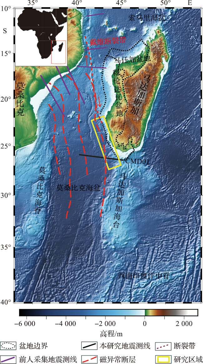
2021年,中国-马达加斯加国际合作航次实施,获得了多条实测重力、磁力和二维多道地震资料。本文选择其中横穿马达加斯加岛西南陆缘的CMD01剖面开展详细的地震剖面解释,通过地形资料和自由空间重力异常(free-air anomaly,FAA)(以下简称重力异常)资料分析以及重震联合反演,构建陆缘地壳密度模型,划分陆缘构造单元,阐明陆缘构造演化过程。现今,划定200海里以外大陆架的外部界限(简称外大陆架划界)事关国家海洋主权权益、资源利用和国家安全,而马达加斯加岛陆缘的地质属性和地壳结构是马达加斯加划界案能否通过的关键点。本研究可深化对冈瓦纳大陆裂解分离过程的认识,明确马达加斯加岛陆缘的地质属性,为马达加斯加大陆架划界提供数据支撑,加强中国-马达加斯加两国在海洋科技领域的合作与交流。
1 区域地质背景
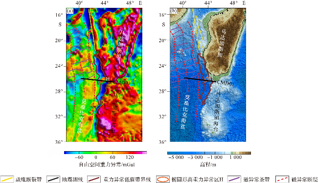
本文研究区为马达加斯加岛西南陆缘,研究区向洋一侧为南北向扩张形成的莫桑比克海盆,该海盆在早侏罗世时期开始扩张,与索马里海盆皆为冈瓦纳大陆裂解以及南北向扩张过程中形成的最古老的深海海盆;研究区南部为脊状地形的马达加斯加海台,玄武岩和拉斑玄武岩证据表明其形成与马里昂热点有关,但其地壳属性目前仍存在争议[8-9];北部与戴维断裂带相接,该断裂带为东非海岸洋壳与陆壳的转换边界,在13°S—23°S 构造特征较为明显,表现为近南北走向,是连接东非海岸与马达加斯加的构造带;东侧发育相邻的穆伦达瓦盆地与马任加盆地,两者均是中生代以来随着冈瓦纳大陆裂解、印度洋形成而产生的沉积盆地,具有明显的双层结构,下部裂谷层系包括上石炭统、二叠系、三叠系及侏罗系,以陆相沉积充填为主,上部坳陷层系为白垩系及新生界,全部为海相沉积充填(图1)。
马达加斯加岛地质背景复杂,受冈瓦纳大陆裂离影响,主要经历了三个阶段:陆内裂谷阶段(晚石炭世至早侏罗世)、马达加斯加漂移阶段(中侏罗世至早白垩世)、被动陆缘阶段(晚白垩世至今)。
2 数据及方法
本研究采用地震剖面构造地层解释和重震联合反演的方法研究马达加斯加岛西南部陆缘地壳结构。基于地震反射、折射以及沿测线的实测重力异常数据,应用重震联合反演软件进行人机交互物性反演,以地震反射、折射剖面作为约束条件,确定关键界面的埋藏深度。通过拟合迭代反演物性结构,使得模型计算的重力异常与实测重力异常数据之间的误差最小,最终得到研究区的地壳密度模型。
2.1 数据来源
本研究使用的多道地震剖面(CMD01)位于马达加斯加岛西南部陆缘(位置见图1),2021年由大洋号采集,剖面长度约为502 km。多道地震电缆长度为6 km,共480道,气枪总体积为0.1 m3,炮间距为37.5 m,采样率为2 ms,记录长度为14 s。通过叠前去噪、地表一致性振幅补偿、直达波压制、多次波组合压制、偏移速度分析和叠前时间偏移等处理方式,获得叠前时间偏移剖面。使用ZL11-A型海洋重力仪同步采集重力数据,使用G880磁力仪同步采集磁力数据。盆地边界数据来源于Energy Portal by S&P Global(https://energyportal.ci.spglobal.com),海底地形和海洋卫星测高重力异常数据来源于全球卫星重力异常数据库(https://topex.ucsd.edu/marine_grav/mar_grav.html),数据的网格间距约为1'×1',局部地区重力异常数据的精度达到1.0 mGal。
2.2 地层界面识别与地壳密度模型建立
2.2.1 关键地质界面识别
表1 马达加斯加岛西南陆缘层序地震反射特征Tab.1 Seismic reflection characteristics of sequence in the southwestern margin of Madagascar Island |
| 层序 | 内部反射特征 | 频率 | 振幅 | 连续性 | 地震相 |
|---|---|---|---|---|---|
| U5(T0~T1) | 平行-亚平行 | 高频,变化较小 | 低-中振幅,局部空白 | 好-中等 | 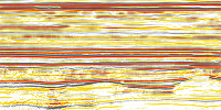 |
| U4(T1~Tb) | 亚平行,局部嘈杂状 | 中频 | 低-中振幅,局部空白 | 中等-差 | 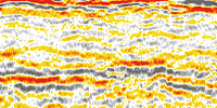 |
| U3(T1~T2) | 平行-亚平行,局部波状 | 高-中频,局部有变化 | 中振幅,局部空白 | 好-中等 | 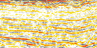 |
| U2(T2~T3) | 亚平行,局部嘈杂状 | 中频 | 中振幅 | 好 |  |
| U1(T3~T4) | 亚平行,局部嘈杂状 | 变化较大 | 高-中振幅 | 好-中等 |  |
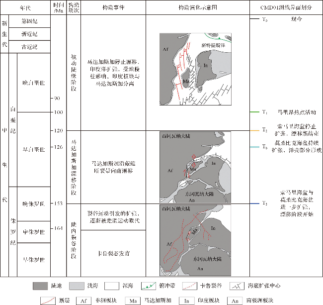
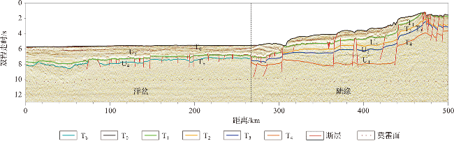
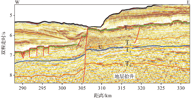
图3 CMD01二维地震剖面(U表示地层,其中U1为T3与T4之间的地层,U2为T2与T3之间的地层,U3为T1和T2之间的地层,U4为T1和Tb之间的地层,U5为T0和T1之间的地层。) Fig.3 CMD01 2D seismic profile (U represents stratum, U1 is the stratum between T3 and T4, U2 is the stratum between T2 and T3, U3 is the stratum between T1 and T2, U4 is the stratum between T1 and Tb, U5 is the stratum between T0 and T1.) |
如图3所示,在CMD01剖面左端起始一直到268 km,可见清晰的声波基底Tb处于双程走时7.1~8.7 s深度。在剖面0~50 km,双程走时10.2 s左右的位置,可见比较强的断续反射,结合前人研究发现的这个区域比较显著的线性磁力异常特征[18-19],我们解释该界面为洋壳的莫霍面。Tb至莫霍面之间的双程走时间隔大致为2 s,与6~7 km的标准洋壳厚度的双程走时2 s相同。从50 km向右,该剖面上的断续反射不再明显,主要根据“10 s规则”来推断莫霍面的位置。WARNER[26]研究了全球洋壳的莫霍面,提出在地震反射走时剖面上,莫霍面的表观符合所谓的“10 s规则”,即地壳处于均衡状态时,莫霍面会相当稳定地出现在双程走时为10 s的深度,并表现出相当的平坦度。莫桑比克海盆属于中生代的洋壳,已达到均衡状态,因此基于上述识别标准和规则,推断CMD01剖面50~268 km区段的莫霍面在双程走时为10~10.2 s的位置。在这个区段,尽管缺乏连续的强反射,但是断续的较强反射仍然模糊可见。在0~268 km区段内,除了局部的洋壳厚度小于2 s双程走时(如50 km处为1.6 s)外,其余洋壳的厚度均在标准洋壳的厚度范围内。从268 km向右,代表莫霍面的断续反射逐渐加深到双程走时10.5 s左右,推断可能与这个区段后来的地幔柱活动有关。
如上所述,Tb为莫桑比克海盆洋壳顶界面,而在莫桑比克海盆中识别出的磁力异常条带M0r,测线洋壳年龄为距今120 Ma左右[18-19]。总体上看,Tb界面在0~268 km区段基本水平延伸,上方存在明显不整合面。在268~500 km区段内,双程走时由7.7 s逐渐向上抬升至2.2 s附近,界面的反射强度不大,中等连续,中间有断层切割而错移,该界面标注为T3。T3界面之下为楔状地层U1,表现为连续性较好的亚平行反射特征,振幅高-中,局部为嘈杂状。T3受同生断层控制,其上沉积层的厚度变化不大,并且还具有对U1的削截反射,由此认为T3为同裂陷地层顶界面和裂后沉积地层底界面,属于马达加斯加西南被动陆缘发育的裂后不整合界面,代表晚侏罗世陆缘张裂活动结束、索马里海盆与莫桑比克海盆扩张开始、洋壳形成以及马达加斯加岛进入漂移阶段。该界面在东非大陆边缘广泛分布,是冈瓦纳大陆破裂形成的不整合面[24-25]。
Tb界面从268 km处向右分开的下支界面被标定为T4,其反射强度和连续性均不及上述T2、T3界面。从地震剖面可见,此T4界面可从268 km处向右直至剖面末端,即268~500 km处均可追踪。值得注意的是,在306~440 km区段,T4界面双程走时逐渐加深,直至8.2 s附近,从440 km向右,双程走时由于断层作用而抬升至4 s附近。T4实际上为声波基底,其下为地壳基底,上为陆缘沉积充填的起始。考虑到冈瓦纳基底的背景,结合相邻陆缘盆地油气勘探揭示的盆地基底,本文将T4界面确定为晚石炭世冈瓦纳陆内裂谷时期的开始。长期的中生代陆内裂谷作用,使T4与上覆侏罗世界面之间沉积了巨厚的地层[23-24]。
在马达加斯加陆缘盆地中,T1界面为最显著的一条强反射界面,与相邻盆地油气勘探资料[3,28⇓-30]的对比分析表明,该界面是早、晚白垩世的分界面。地球化学与岩石学数据分析表明,此时马里昂热点产生了剧烈的岩浆活动[8-9],并形成大量熔岩流,使沉积环境发生剧烈变化,导致了该界面在地震剖面上的强反射和显著发育。同时,由于该界面的屏蔽效应,使得下伏地层的地震反射明显弱化。T1界面在整个研究区都能够连续识别,表现为强振幅、连续的地震反射特征。在剖面的0~268 km,T1双程走时在7~8 s附近;在268~500 km,双程走时不断抬升,最高至1.2 s。受戴维断裂带走滑运动的影响,剖面中洋壳部分的年龄大致为距今120 Ma,洋盆中不存在T2界面,因此界面T1下伏U3与U4两组不同地层。其中,U3以界面T2为底界面,存在于陆缘部分,为后漂移沉积,地震反射表现为平行-亚平行的局部波状反射,连续性较好,中振幅,存在部分空白区域;U4以界面Tb为底界面,存在于洋盆部分,厚度薄于U3,内部表现为亚平行状、局部嘈杂状反射,连续性中等-差,振幅低-中等,局部区域存在空白反射。
T0为现今海底面,是沉积地层和海水的分界面。在二维地震剖面上(由陆向洋方向),T0界面不断加深,在洋盆区域变化不明显,坡度较小;在洋陆边界附近抬升明显,表明陆架存在明显陡坡。T0下伏地层U5,以T1为底界面,地震反射特征表现为平行-亚平行,连续性较好,振幅较低,受T1界面的强振幅屏蔽,部分区域呈现空白反射。
2.2.2 重震联合反演
表2 马达加斯加岛西南部陆缘地壳密度与速度模型[7,28-29]Tab.2 Crustal density model and velocity model of the southwestern margin of Madagascar Island[7,28-29] |
| 地层 | 密度/(g·cm-3) | 层速度/(m·s-1) |
|---|---|---|
| 海水 | 1.03 | 1 500 |
| 沉积层1 | 2.20 | 2 000 |
| 沉积层2 | 2.30~2.45 | 3 300 |
| 沉积层3 | 2.52~2.56 | 3 500 |
| 沉积层4 | 2.57~2.64 | 4 000 |
| 洋壳 | 2.93 | 6 500 |
| 上地壳 | 2.67~2.74 | 5 700~6 300 |
| 下地壳 | 2.90~2.94 | 6 400~7 000 |
| 下地壳高密度体 | 3.10~3.16 | 7 000~7 500 |
| 地幔 | 3.30 | 8 000~8 100 |
3 结果
3.1 区域地形和重力特征
3.2 CMD01地震反射特征
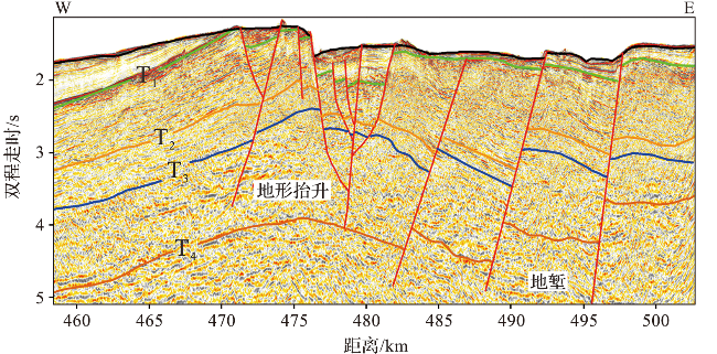
图5为测线CMD01多道地震剖面和对应的实测重力、磁力异常。图6为图5中洋陆过渡区地震剖面的局部放大。根据前文所述,在268 km这个位置Tb 被截断,向陆方向分支为两个不整合面,分别为向上抬升的T3和向下延伸的T4两条分支界面。268 km处还发育了近直立的断层,该断层可能为转换断层戴维断裂带的马尾状延伸。基于上述特征,以该断层作为洋陆边界,左侧为洋盆部分,右侧为马达加斯加陆缘部分。向陆方向的重力异常先升高后逐渐下降,洋盆内重力异常整体无大幅度变化,受深部构造影响存在较小起伏。图7显示,剖面的26~68 km段,T1呈现下陷趋势,重力异常值由东向西减小,位置与下陷区域一致,判断该位置为拗陷构造;剖面75~87 km,重力异常曲线隆起,并且二维地震剖面显示有明显的岩浆活动痕迹,在深部形成的侵入体刺穿T1并破坏Tb的连续性。图8显示,剖面290~315 km可识别出多条走滑断层,断层右侧(向陆一侧)地形与地层出现抬升,此时重力异常急剧升高,磁力异常迅速降低后迅速升高至>400 nT。由于该区段内无明显岩浆活动痕迹,因此认为影响重力、磁力异常曲线变化的物质可能位于地壳深部。在306 km处,漂移期沉积U2被截断,T2界面尖灭。从320 km向右,重力异常不增反降直至425 km,425~500 km,重力异常曲线上升(图5c),根据二维地震剖面推断是受到了地形和基底抬升的影响。其中,在470~485 km的地形抬升处可识别出代表走滑断层的花状结构,且断层两侧地层倾向相反,表明该位置疑似存在早期压扭走滑,晚期转为张扭的过程,使地形发生改变,并生成地堑结构(图9)。
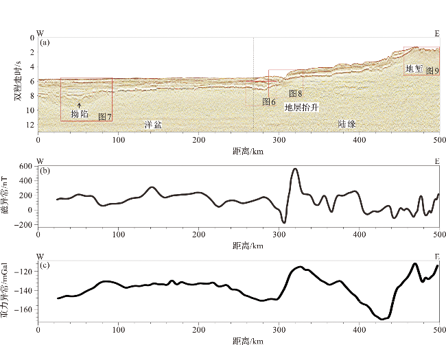
图5 CMD01的二维地震剖面(a)、磁力异常曲线(b)和自由空间重力异常曲线(c)Fig.5 CMD01 2D seismic profile (a), magnetic anomaly curve (b) and gravity anomaly curve (c) |
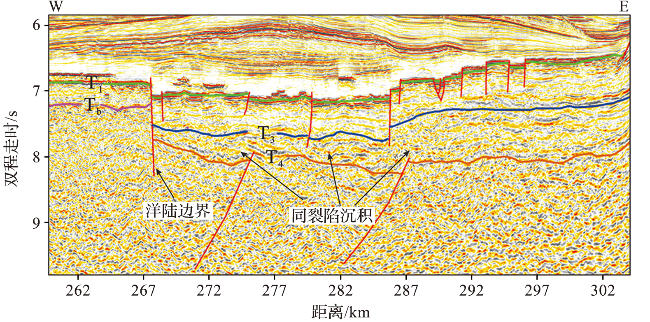
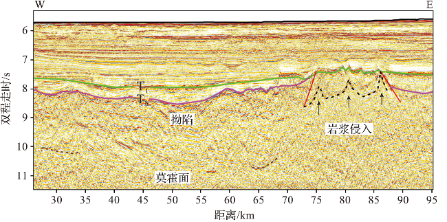
图7 测线CMD01海盆内拗陷区与岩浆侵入的地震剖面Fig.7 Rift area and magmatic intrusions within the basin in CMD01 seismic profile |
3.3 重震联合反演
对基于时深转换得到的深度剖面进行重震联合反演,得到地壳密度模型(以下简称模型),并对其反演的莫霍面深度进行评估。将反演莫霍面(绿色实线)与时深转换后的莫霍面(蓝色虚线)进行对比,发现两条线在起伏趋势上基本相似,但在300~400 km存在最大约3 km的深度差距(图10c),而在该区域,重力异常曲线(图10b)也表现出与两侧明显不同,存在明显的升高趋势,因此,猜想在该区域深部可能存在异常体。为了验证该猜想,在不改变原模型其他反演层位深度以及地层密度的前提下,在300~400 km之间添加一层下地壳高密度体作为新模型,新模型反演的莫霍面深度(图10e)与基于时深转换的莫霍面深度趋于一致。图10d显示,重力异常实测值(黑色实线)为-170 ~-113 mGal,由陆向洋方向上变化明显,在洋壳区域和陆壳区域呈现明显的分带特征。新模型的拟合误差为0.727 mGal。结合CMD01地壳密度模型和自由空间重力异常,马达加斯加西南陆缘可以划分为减薄陆壳区、洋陆过渡带、洋壳区三个陆缘构造单元。
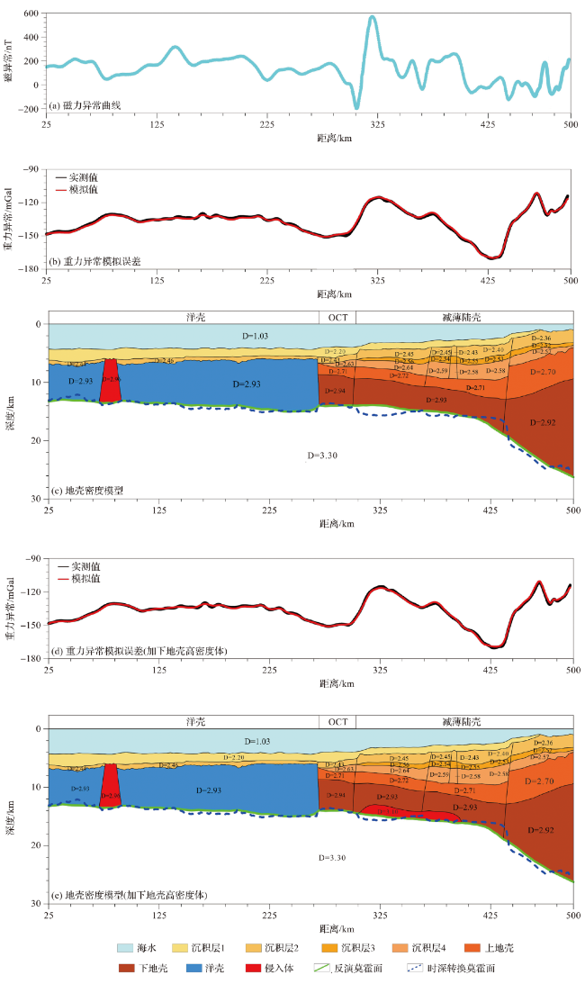
1)减薄陆壳区
在模型的425~500 km之间,重力异常值的变化范围在-112 ~-170 mGal之间,形成了由陆向洋方向的第一个重力异常峰值区,对应莫霍面埋深变化明显,由25 km抬升至16 km。由于结晶基底向洋方向缓慢下降,地壳厚度由22 km减薄至8 km,属于典型的减薄型陆壳。各地层厚度在该区域内的变化不同,沉积层1在470~500 km之间被完全剥蚀;沉积层2厚度变化不明显;沉积层3无明显变化;沉积层4逐渐增厚。
在模型的303~425 km之间,重力异常值在-115~-170 mGal之间变化,是第二个重力异常峰值区,曲线变化坡度相比第一个峰值区较缓。通过模型拟合发现,导致重力异常抬升的原因是在该区域下地壳中存在高密度体,该高密度体位于模型300~400 km,厚度最大为2 km。在该区域的磁力异常曲线上也有较明显的变化(图10a)。莫霍面深度由16 km抬升至14 km,地壳厚度由8 km减薄至6 km,沉积层3和沉积4厚度逐渐变小。
2)洋陆过渡带
洋陆过渡带位于模型268~303 km,在洋壳和减薄陆壳之间,重力异常曲线先减小后增加形成了碗状结构。相较于减薄陆壳区,莫霍面变化不明显,地壳厚度大致为7 km,其与洋壳以断层为界,与减薄陆壳以一个大型走滑断层带为界。
3)洋壳区
洋壳区位于模型左侧25~268 km之间,重力异常的变化范围在-150 ~-130 mGal之间,变化幅度与陆壳相比明显较缓,其中75~85 km之间隆起,该区域对应二维地震剖面上有明显的岩浆活动痕迹(图7)。洋壳区磁力异常较减薄陆壳区平缓,表现为明显的洋壳特征,洋壳厚度在6~8 km之间。
4 讨论
4.1 下地壳高密度体成因
地壳密度模型,由浅到深分别为海水层、沉积层、地壳层与地幔层,模型中的侵入体为侵入岩与下地壳高密度体。
所以,我们更倾向于认为CMD01剖面地壳密度模型中的异常体为岩浆底侵形成的下地壳高密度体,主要的原因分析如下。侏罗纪时期,冈瓦纳大陆受到地幔柱的显著影响开始裂离,同时伴随着强烈的岩浆活动,形成了典型的火山型陆缘,如莫桑比克中部陆缘,其洋陆过渡带中发育有向海倾斜的反射层和下地壳高速体[29,41];根据马达加斯加岛西部的穆伦达瓦盆地的深部地震资料,发现在洋陆过渡带和陆壳区域内存在下地壳高速体,最大厚度可达4.1 km[28];共轭陆缘(坦桑尼亚-北莫桑比克陆缘)二维地震剖面深部的反射结构与重震联合反演的地壳密度模型都表明其洋陆过渡带深部发生了岩浆底侵增生[6]。目前发现的大面积岩浆活动主要集中于莫桑比克中部与南部,而坦桑尼亚陆缘洋壳下方的底侵表明马达加斯加岛陆缘在裂离过程中同样存在岩浆活动,只不过由于该处岩浆活动的强度不及莫桑比克中部陆缘而未形成火成岩省或向海倾斜的反射层。
4.2 陆缘结构单元的地壳特征
根据实测重力数据和反演结果(图10)可知,减薄陆壳区域位于303~500 km之间,约为197 km,范围较宽,地壳底部岩浆侵入形成厚度约为2 km左右的下地壳高密度体,重力异常变化幅度大,呈现多个峰值,莫霍面埋深与地壳厚度的变化明显;洋陆过渡带位于268~303 km内,宽度约为35 km,向洋方向重力异常曲线逐渐平缓,莫霍面埋深无明显变化,与洋壳和陆壳之间以断层为界;洋壳区位于25~268 km,重力异常变化小,地壳厚度变化约为2 km,重力、磁力异常呈现明显的洋壳特征。
以上陆缘结构单元的地壳特征表明,马达加斯加陆缘的洋陆过渡带较窄,没有出现贫岩浆型被动大陆边缘宽阔的地幔剥露[34,42-43],或富岩浆型被动大陆边缘向海倾斜的火山岩层、岩浆底侵形成的下地壳高速体和大量火成岩体[44-45]。受控于走滑断裂带,紧邻转换断层的洋壳厚度相对于正常洋壳明显较薄,因此属于转换陆缘,其发育受戴维断裂带走滑运动的影响,是在马达加斯加岛与非洲大陆分离的过程中,在从拉张运动转变为走滑运动的时期发育形成的。陆壳区薄且范围较宽,推断可能是受拉张运动的影响,原因如下:1)在多道地震剖面中减薄陆壳部分能够识别出的走滑断层多为小型断层且较为模糊,缺少确切的大型走滑断层,不符合走滑运动主导的减薄陆壳特征;2)陆缘演化过程表明,在拉张运动转变为走滑运动时,大部分陆缘已发育完全,因此戴维断裂带的走滑运动主要破坏洋壳与洋陆过渡带,对陆壳的影响较小[18,46]。
4.3 马达加斯加岛西南部陆缘演化
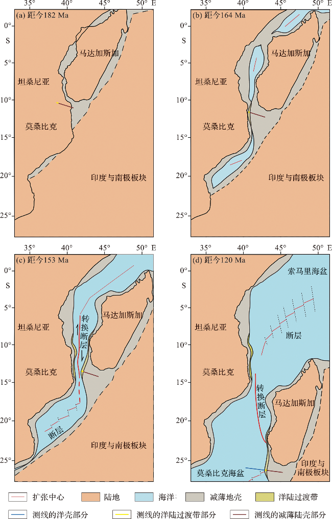
在距今164 Ma,马达加斯加西部陆缘首先受到东、西冈瓦纳大陆张裂控制,形成了张裂型陆缘[2,47⇓-49],本研究中的减薄陆壳区也在此张裂过程中形成。大量的研究表明沿戴维断裂带的走滑运动是形成转换型陆缘的重要机制[6-7,19,28,50-51]。REEVES 等[2]在坦桑尼亚陆缘南部的二维地震剖面中发现戴维断裂带的东西两侧分别存在不同时期的洋壳,认为东、西冈瓦纳大陆最早的张裂运动方向是NW—SE向,伸展方向大致垂直于断裂带,在发生马达加斯加岛漂移运动前,先行的裂谷运动已经形成了扩张中心与洋壳。SINHA 等[6]通过多道地震剖面在坦桑尼亚近海找到了疑似裂谷时期的扩张中心,佐证了该观点(图11b)。
5 结论
通过对马达加斯加岛西南部陆缘的实测重力、地震剖面构造地层解释和在此基础上的重震联合反演研究,结合磁力异常特征综合分析,得到以下几点结论。
1)剖面CMD01的地壳密度模型内存在下地壳高密度体,与重力异常剖面中的椭圆高重力异常区对应,底侵的岩浆来源于冈瓦纳大陆裂解初期的岩浆活动,不同陆缘的岩浆活动程度不同。
2)CMD01剖面根据重力异常曲线、地层和地壳厚度等信息,由洋向陆划分为洋壳、洋陆过渡带、减薄陆壳三个区域。其中,洋陆过渡带位于两者之间,宽度大致为35 km,地壳厚度薄至7 km,推测是受戴维断裂带走滑运动影响,具备部分转换型洋陆过渡带的特征。
3)地壳密度模型内减薄陆壳宽度约为197 km,洋陆过渡带宽度约为35 km,较窄的洋陆过渡带与较广的减薄陆壳表明,马达加斯加岛西南部陆缘在演化过程中存在拉张运动向走滑运动的转变。