海洋学研究 ›› 2023, Vol. 41 ›› Issue (4): 21-31.DOI: 10.3969/j.issn.1001-909X.2023.04.003
基于海气耦合模式的超强台风“山竹”数值模拟
吕曌1( ), 伍志元1,2,3,*(), 蒋昌波1,3,4, 张浩键1, 高凯1, 颜仁1
- 1.长沙理工大学 水利与环境工程学院,湖南 长沙 410114
2.大连理工大学 海岸和近海工程国家重点实验室,辽宁 大连 116024
3.水沙科学与水灾害防治湖南省重点实验室,湖南 长沙 410114
4.湖南工业大学 土木工程学院,湖南 株洲 412007
-
收稿日期:2022-12-20修回日期:2023-03-20出版日期:2023-12-15发布日期:2024-01-30 -
通讯作者:伍志元(1989—),男,副教授,主要从事海岸、海洋动力过程及其模拟技术研究,E-mail:zwu@csust.edu.cn 。 -
作者简介:吕曌(1996—),男,河南省安阳市人,主要从事海岸动力过程研究,E-mail:18840820425@163.com。 -
基金资助:国家重点研发计划项目(2021YFB2601100);国家自然科学基金项目(51839002);国家自然科学基金项目(52171246);大连理工大学海岸与近海工程国家重点实验室开放基金(LP2005);湖南省自然科学基金项目(2022JJ20041);水利部粤港澳大湾区水安全保障重点实验室开放研究基金资助项目(WSGBA-KJ2023012);湖南省科技创新计划(2023RC3136);国家级大学生创新训练计划项目(S202310536020)
Numerical investigation of the super typhoon Mangkhut based on the coupled air-sea model
LÜ Zhao1(), WU Zhiyuan1,2,3,*(), JIANG Changbo1,3,4, ZHANG Haojian1, GAO Kai1, YAN Ren1
- 1. School of Hydraulic and Environmental Engineering, Changsha University of Science & Technology, Changsha 410114, China
2. State Key Laboratory of Coastal and Offshore Engineering, Dalian University of technology, Dalian 116024, China
3. Key Laboratory of Water-Sediment Sciences and Water Disaster Prevention of Hunan Province, Changsha 410114, China
4. School of Civil Engineering, Hunan University of Technology, Zhuzhou 412007, China
-
Received:2022-12-20Revised:2023-03-20Online:2023-12-15Published:2024-01-30
摘要:
基于中尺度大气模式WRF和区域海洋模式ROMS,构建WRF-ROMS海气双向耦合模式,针对2018年超强台风“山竹”进行模拟。利用观测数据对台风路径和强度进行验证,结果表明海气耦合模式对台风“山竹”的模拟相对单一模式有更高的精度,耦合模式得到的台风路径与最佳路径吻合良好,误差控制在60 km以内;获取的风速和海平面气压结果也较单一模式更为准确。基于海气耦合模拟结果,进一步分析台风作用下风场、气压场、海表流场和风暴增水的时空分布特征,结果表明:1)空间分布方面,台风进入南海后,七级风圈半径在台风沿路径右后方较大;气旋式流场与台风风场呈现出显著的埃克曼效应,流向与风向呈45°;风场、气压场、风生流场和增水分布均存在明显的不对称性,台风路径右侧的台风强度、流速和增水均大于左侧。2)时间分布方面,风场与气压场分布特征相似且与台风中心保持同步,流场和近岸风暴增水相对台风路径存在3 h左右的滞后。
中图分类号:
引用本文
吕曌, 伍志元, 蒋昌波, 张浩键, 高凯, 颜仁. 基于海气耦合模式的超强台风“山竹”数值模拟[J]. 海洋学研究, 2023, 41(4): 21-31.
LÜ Zhao, WU Zhiyuan, JIANG Changbo, ZHANG Haojian, GAO Kai, YAN Ren. Numerical investigation of the super typhoon Mangkhut based on the coupled air-sea model[J]. Journal of Marine Sciences, 2023, 41(4): 21-31.
| 物理选项 | 参数化方案 |
|---|---|
| 云微物理方案(mp_physics) | WSM 6-class graupel方案 |
| 长波辐射(ra_lw_physics) | RRTMG方案 |
| 短波辐射(ra_sw_physics) | RRTMG方案 |
| 表面层物理选项(sf_sfclay_physics) | Monin-Obukhov方案 |
| 地表陆面方案(sf_surface_physics) | Noah地表模型 |
| 行星边界层(bl_pbl_physics) | YSU方案 |
| 积云参数(cu_physics) | Kain-Fritsch方案 |
表1 WRF模式物理参数化方案配置
Tab.1 Configuration of the physical parameterization schemes in the WRF model
| 物理选项 | 参数化方案 |
|---|---|
| 云微物理方案(mp_physics) | WSM 6-class graupel方案 |
| 长波辐射(ra_lw_physics) | RRTMG方案 |
| 短波辐射(ra_sw_physics) | RRTMG方案 |
| 表面层物理选项(sf_sfclay_physics) | Monin-Obukhov方案 |
| 地表陆面方案(sf_surface_physics) | Noah地表模型 |
| 行星边界层(bl_pbl_physics) | YSU方案 |
| 积云参数(cu_physics) | Kain-Fritsch方案 |

图1 耦合模式计算区域及嵌套网格示意图 (蓝色实线表示WRF嵌套网格,红色虚线表示ROMS嵌套网格。)
Fig.1 The simulation domain and nested grids of the coupled air-sea model (The blue solid line represents the WRF nested grid,and the red dashed line represents the ROMS nested grid.)

图2 不同模式下超强台风“山竹”模拟路径与最佳路径的对比
Fig.2 Comparison between the simulated track and the best track of super typhoon Mangkhut in different models

图3 模式与最佳路径数据集的台风中心气压和近中心最大风速对比 (竖向虚线代表台风登陆时刻。)
Fig.3 Comparison of typhoon central pressure and maximum wind speed from the models with those from the best-track dataset (Vertical dashed line represents the time of typhoon landfall.)

图4 两组试验模拟路径与最佳路径的误差 (竖向虚线代表台风登陆时刻。)
Fig.4 Comparison of the bias of the track simulated by two different models with that from the best-track dataset (Vertical dashed line represents the time of typhoon landfall.)

图5 超强台风“山竹”影响期间风速、海平面气压、潮位测站分布位置示意图
Fig.5 Distribution diagram of wind speed, sea level pressure and tide stations during the influence of super typhoon Mangkhut

图6 模拟风速与实测风速时程对比
Fig.6 Time series comparison between models’ wind speed and observed wind speed

图7 模拟与浮标实测海平面气压时程对比
Fig.7 Time series comparison between sea level pressure by models with that by buoy stations

图8 耦合模式下超强台风“山竹”的气压场和风场的空间分布
Fig.8 Spatial distribution of the pressure and wind field in coupled model during super typhoon Mangkhut

图9 台风风场及风生流场的空间分布 (表示台风中心; 表示流场中心。)
Fig.9 Spatial distribution of typhoon wind fields and wind-generated current fields ( represents the typhoon center; represents the center of the flow field.)
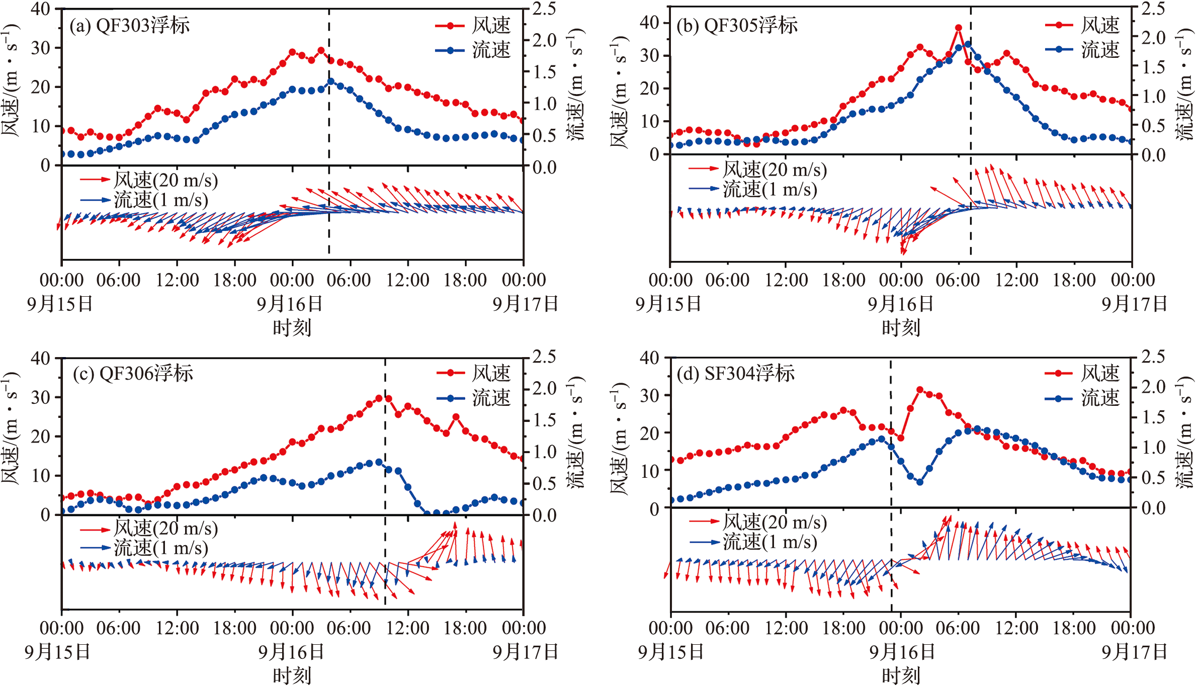
图10 特征站点风速、流速以及风向、流向历时曲线对比 (黑色虚线表示台风途经站点时刻。)
Fig.10 Comparison of wind speed and current velocity as well as wind direction and current direction at the stations (The black dotted line indicates the time when the typhoon passes through the stations.)

图11 近岸验潮站天文潮及风暴潮水位验证
Fig.11 Validation of results for astronomical and storm tide levels at nearshore tide gauge stations

图12 海表流场和台风引起的风暴增水的空间分布 (表示台风中心; 表示流场中心。)
Fig.12 Spatial distribution of sea surface current fields and surge caused by super typhoon Mangkhut ( represents the typhoon center; represents the center of the flow field.)
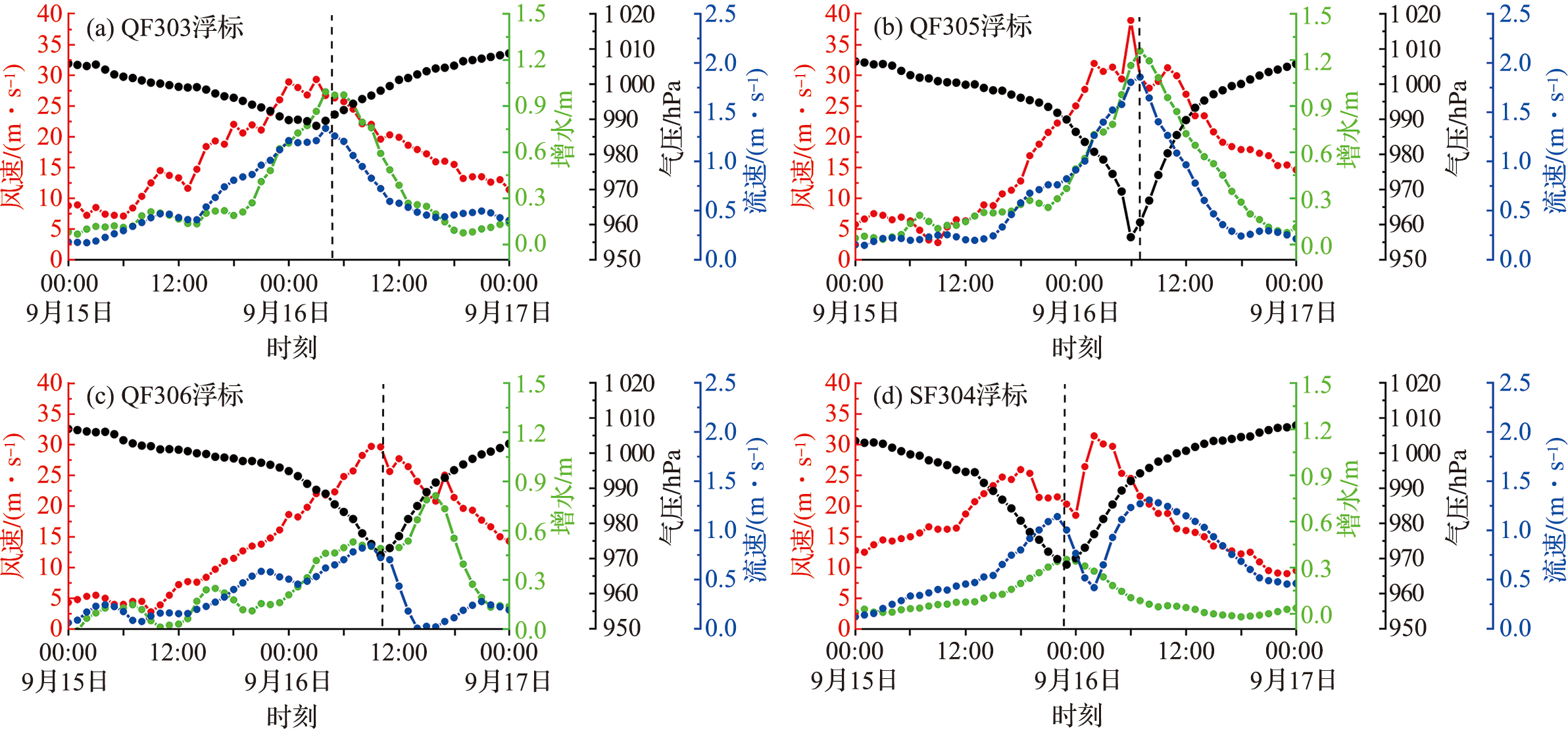
图13 特征站点风速、气压、流速及风暴增水历时曲线 (黑色虚线表示台风途经站点时刻。)
Fig.13 Time series of wind speed, pressure, current velocity and storm surge at the stations (The black dotted line indicates the time when the typhoon passes through the stations.)
| [1] |
MUIS S, VERLAAN M, WINSEMIUS H C, et al. A global reanalysis of storm surges and extreme sea levels[J]. Nature Communications, 2016, 7: 11969.
DOI PMID |
| [2] |
WANG Y B, LIU J Q, DU X, et al. Temporal-spatial characteristics of storm surges and rough seas in coastal areas of China’s Mainland from 2000 to 2019[J]. Natural Hazards, 2021, 107(2): 1273-1285.
DOI |
| [3] |
SHI X W, HAN Z Q, FANG J Y, et al. Assessment and zonation of storm surge hazards in the coastal areas of China[J]. Natural Hazards, 2020, 100(1): 39-48.
DOI |
| [4] | 段自强, 李永平, 于润玲, 等. 海洋飞沫方案改进对台风“威马逊”强度预报的影响[J]. 海洋与湖沼, 2016, 47(6):1075-1090. |
| DUAN Z Q, LI Y P, YU R L, et al. On tropical cyclone intensity forecast using improved sea spray scheme in regional atmosphere-wave coupled model[J]. Oceanologia et Limnologia Sinica, 2016, 47(6): 1075-1090. | |
| [5] | 丁瑞, 朱良生. 条件变化对海口湾风暴增水的影响分析:以海鸥台风为例[J]. 海洋工程, 2018, 36(4):147-154. |
| DING R, ZHU L S. Impact of condition on storm surge in the Haikou Bay[J]. The Ocean Engineering, 2018, 36(4): 147-154. | |
| [6] | ZHANG W Z, LIN S, JIANG X M. Influence of tropical cyclones in the western North Pacific[M]//LUPO A R. Recent developments in tropical cyclone dynamics, prediction, and detection. InTech, 2016: 3-24. |
| [7] |
EZER T. On the interaction between a hurricane, the Gulf Stream and coastal sea level[J]. Ocean Dynamics, 2018, 68(10): 1259-1272.
DOI |
| [8] | 张浩键, 伍志元, 刘晓建, 等. 台风“天鸽”影响下珠江口水动力过程数值模拟研究[J]. 长沙理工大学学报:自然科学版, 2023, 20(4):142-152. |
| ZHANG H J, WU Z Y, LIU X J, et al. Numerical simulation of hydrodynamic processes in the Pearl River Estuary influenced by Typhoon “Hato”[J]. Journal of Changsha University of Science & Technology: Natural Science, 2023, 20(4): 142-152. | |
| [9] |
LIN S, ZHANG W Z, SHANG S P, et al. Ocean response to typhoons in the western North Pacific: Composite results from Argo data[J]. Deep Sea Research Part I: Oceanographic Research Papers, 2017, 123: 62-74.
DOI URL |
| [10] | JANSSEN P. The interaction of ocean waves and wind[M]. Cambridge, UK: Cambridge University Press, 2004. |
| [11] | 叶芳, 刘磊, 马占宏, 等. 不同环境风场条件下冷尾流对台风强度的影响[J]. 热带气象学报, 2017, 33(3):368-374. |
| YE F, LIU L, MA Z H, et al. Effect of cold wake on typhoon intensity in different environmental wind fields[J]. Journal of Tropical Meteorology, 2017, 33(3): 368-374. | |
| [12] |
ZHAO X H, CHAN J C L. Changes in tropical cyclone intensity with translation speed and mixed-layer depth: Idealized WRF-ROMS coupled model simulations[J]. Quarterly Journal of the Royal Meteorological Society, 2017, 143(702): 152-163.
DOI URL |
| [13] | SHEN W X, GINIS I. Effects of surface heat flux-induced sea surface temperature changes on tropical cyclone intensity[J]. Geophysical Research Letters, 2003, 30(18): 1933. |
| [14] |
CHEN S E, CAMPBELL T J, JIN H, et al. Effect of two-way air-sea coupling in high and low wind speed regimes[J]. Monthly Weather Review, 2010, 138(9): 3579-3602.
DOI URL |
| [15] |
MOHANTY S, NADIMPALLI R, OSURI K K, et al. Role of sea surface temperature in modulating life cycle of tropical cyclones over bay of Bengal[J]. Tropical Cyclone Research and Review, 2019, 8(2): 68-83.
DOI URL |
| [16] | 蒋小平, 刘春霞, 齐义泉. 利用一个海气耦合模式对台风Krovanh的模拟[J]. 大气科学, 2009, 33(1):99-108. |
| JIANG X P, LIU C X, QI Y Q. The simulation of typhoon Krovanh using a coupled air-sea model[J]. Chinese Journal of Atmospheric Sciences, 2009, 33(1): 99-108. | |
| [17] |
WARNER J C, ARMSTRONG B, HE R Y, et al. Development of a coupled ocean-atmosphere-wave-sediment transport (COAWST) modeling system[J]. Ocean Modelling, 2010, 35(3): 230-244.
DOI URL |
| [18] | 伍志元, 蒋昌波, 邓斌, 等. 基于海气耦合模式的南中国海北部风暴潮模拟[J]. 科学通报, 2018, 63(33):3494-3504. |
| WU Z Y, JIANG C B, DENG B, et al. Simulation of the storm surge in the South China Sea based on the coupled sea-air model[J]. Chinese Science Bulletin, 2018, 63(33): 3494-3504. | |
| [19] |
MOONEY P A, MULLIGAN F J, BRUYÈRE C L, et al. Investigating the performance of coupled WRF-ROMS simulations of Hurricane Irene (2011) in a regional climate modeling framework[J]. Atmospheric Research, 2019, 215: 57-74.
DOI URL |
| [20] |
WU Z Y, JIANG C B, DENG B, et al. Numerical investigation of Typhoon Kai-tak (1213) using a mesoscale coupled WRF-ROMS model[J]. Ocean Engineering, 2019, 175: 1-15.
DOI URL |
| [21] |
WU Z Y, JIANG C B, DENG B, et al. Numerical investi-gation of Typhoon Kai-tak (1213) using a mesoscale coupled WRF-ROMS model— Part Ⅱ: Wave effects[J]. Ocean Engineering, 2020, 196: 106805.
DOI URL |
| [22] | 李心雨, 杨昀, 李自如, 等. WRF大气模式与台风经验模型在超强台风“山竹”过程重构中的比较分析[J]. 海洋工程, 2022, 40(4):53-64,111. |
| LI X Y, YANG Y, LI Z R, et al. Comparative analyses on reconstructed processes of super typhoon Mangkhut using the WRF atmospheric model and typhoon empirical models[J]. The Ocean Engineering, 2022, 40(4): 53-64, 111. | |
| [23] | 陈晓斐, 齐琳琳, 何尽解, 等. 海洋垂直混合对中尺度海气浪耦合模式预报效果的敏感性试验[J]. 热带气象学报, 2018, 34(6):845-855. |
| CHEN X F, QI L L, HE J J, et al. A study of sensitivity to the choices of vertical mixing parameterizations in a coupled atmosphere-ocean-wave model[J]. Journal of Tropical Meteorology, 2018, 34(6): 845-855. | |
| [24] | LI Z N, TAM C Y, LI Y B, et al. How does air-sea wave interaction affect tropical cyclone intensity? An atmosphere-wave-ocean coupled model study based on super typhoon Mangkhut (2018)[J]. Earth and Space Science, 2022, 9(3): e2021EA002136. |
| [25] | 于玲玲, 麦健华, 程正泉, 等. 热带气旋大风风圈半径非对称性特征及成因简析[J]. 气象学报, 2022, 80(6):896-908. |
| YU L L, MAI J H, CHENG Z Q, et al. Analysis on the asymmetric characteristics and causes of the wind circle radius of tropical cyclones[J]. Acta Meteorologica Sinica, 2022, 80(6): 896-908. | |
| [26] |
LIU J L, ZHANG H, ZHONG R, et al. Impacts of wave feedbacks and planetary boundary layer parameterization schemes on air-sea coupled simulations: A case study for Typhoon Maria in 2018[J]. Atmospheric Research, 2022, 278: 106344.
DOI URL |
| [1] | 张良斌, 屈科, 黄竞萱, 王旭, 虢磊. 风对孤立波海堤越浪特性影响的数值模拟研究[J]. 海洋学研究, 2023, 41(4): 32-45. |
| [2] | 周益飞, 廖光洪. 基于GHSOM网络的南海风场时空变化特征分析[J]. 海洋学研究, 2022, 40(2): 19-31. |
| [3] | 张宸浩, 张明亮, 柴崇顼, 等. 基于OpenFOAM波浪—植物相互作用的数值模拟研究[J]. 海洋学研究, 2022, 40(1): 42-52. |
| [4] | 徐浩波, 管清胜, 许明珠, 刁云云, . 蛇纹岩化作用对超慢速洋中脊拆离断层发育的影响[J]. 海洋学研究, 2021, 39(3): 21-30. |
| [5] | 王维扬, 唐勇, 任建业, 李赫, 赵阳慧, 方银霞, . 南海西南次海盆被动陆缘构造单元划分及伸展演化过程[J]. 海洋学研究, 2021, 39(3): 31-43. |
| [6] | 陈莹, 赵辉, . 南海中西部叶绿素时空变化特征分析[J]. 海洋学研究, 2021, 39(3): 84-94. |
| [7] | 方明豹, 黄佳钰, 杨万康, 孙纯键. 海岛核电厂址的设计基准洪水位研究[J]. 海洋学研究, 2020, 38(4): 80-87. |
| [8] | 周炜, 宣基亮, 黄大吉. 桑沟湾邻近海域岬角潮余流涡对及其产生机理[J]. 海洋学研究, 2020, 38(3): 10-20. |
| [9] | 陆怡, 初凤友, 董彦辉, 朱志敏, 朱继浩, 鲁江姑. 南海东北部陆坡结核成因及对冷泉活动的指示[J]. 海洋学研究, 2020, 38(2): 16-25. |
| [10] | 粟丽, 陈作志, 黄梓荣, 许友伟. 2015年春季南海北部陆架海域网采浮游植物群落结构及其与环境因子关系[J]. 海洋学研究, 2019, 37(3): 86-96. |
| [11] | 伍志元, 蒋昌波, 何智勇, 陈杰, 邓斌, 谢振东. 大气-海浪耦合模式及其在理想台风模拟中的应用研究[J]. 海洋学研究, 2019, 37(2): 9-15. |
| [12] | 刘丛舒, 丁巍伟, 殷绍如, 方鹏高, 丁航航. 南海北部陆坡区海底峡谷地貌、沉积特征及控制因素[J]. 海洋学研究, 2019, 37(2): 28-43. |
| [13] | 李海龙, 吴招才, 许明炬. 南海东北部陆缘地壳结构特征及下地壳高速层成因[J]. 海洋学研究, 2019, 37(2): 44-56. |
| [14] | 刘源, 邱振戈, 栾奎峰, 侍炯, 朱卫东, 刘鲁燕, 沈蔚, 曹彬才. 基于地理加权回归模型的水深反演算法研究[J]. 海洋学研究, 2018, 36(4): 35-42. |
| [15] | 苏银秋, 潘国富, 俞亮亮, 杨万康. 海湾水交换对取排水工程的响应[J]. 海洋学研究, 2018, 36(4): 76-83. |
| 阅读次数 | ||||||
|
全文 |
|
|||||
|
摘要 |
|
|||||