海洋学研究 ›› 2024, Vol. 42 ›› Issue (2): 91-103.DOI: 10.3969/j.issn.1001-909X.2024.02.009
基于高、低潮位的西江感潮河段潮汐特征分析
武家兴1,2,3, 彭棋3, 张卓1,2,3,*, 陈欣颖1,2,3, 陈鹏1,2,3, 温亚娟1,2,3, 王浩丞1,2,3, 张璐1,2,3
- 1.南京师范大学 虚拟地理环境教育部重点实验室,江苏 南京 210023
2.江苏省地理信息资源开发与利用协同创新中心,江苏 南京 210023
3.河海大学 海岸灾害及防护教育部重点实验室,江苏 南京 210023
-
收稿日期:2023-07-23修回日期:2024-02-26出版日期:2024-06-15发布日期:2024-08-09 -
通讯作者:张卓 -
作者简介:*张卓(1981—),男,副教授,主要从事河口海岸动力学研究,E-mail: Mercury1214@126.com。
武家兴(1996—),男,安徽省肥西县人,主要从事河口海岸动力学研究,E-mail: Wujx06@126.com。 -
基金资助:海岸灾害及防护教育部重点实验室(河海大学)开放研究基金面上项目(202218);国家自然科学基金项目(42171465)
Analysis of the tidal characteristics along the tidal reach of Xijiang River based on high and low tide levels
WU Jiaxing1,2,3, PENG Qi3, ZHANG Zhuo1,2,3,*, CHEN Xinying1,2,3, CHEN Peng1,2,3, WEN Yajuan1,2,3, WANG Haocheng1,2,3, ZHANG Lu1,2,3
- 1. Key Laboratory of Virtual Geographic Environment, MOE, Nanjing Normal University, Nanjing 210023,China
2. Jiangsu Center for Collaborative Innovation in Geographical Information Resource Development and Application, Nanjing 210023, China
3. Key Laboratory of Coastal Disaster and Defence, MOE, Hohai University, Nanjing 210023, China
-
Received:2023-07-23Revised:2024-02-26Online:2024-06-15Published:2024-08-09 -
Contact:ZHANG Zhuo
摘要:
通过对高、低潮位数据插值和NS_TIDE模型应用,分析西江感潮河段(马口—大横琴)的潮汐特征。对比三种插值方法发现,相对于三次样条插值法和线性插值法,Hermite插值法对逐时潮位的模拟效果最佳。潮位验证结果显示NS_TIDE模型总体误差较低,异常值主要是源自台风和洪水的影响。西江感潮河段平均水位和分潮振幅存在洪、枯季差异,上游受径流的影响大于潮汐,下游则相反;径流量和潮差增大,促进上游河段平均水位增高,对分潮振幅和迟角的影响在不同河段表现不同,主要与其所处空间位置和分潮自身频率有关。
中图分类号:
引用本文
武家兴, 彭棋, 张卓, 陈欣颖, 陈鹏, 温亚娟, 王浩丞, 张璐. 基于高、低潮位的西江感潮河段潮汐特征分析[J]. 海洋学研究, 2024, 42(2): 91-103.
WU Jiaxing, PENG Qi, ZHANG Zhuo, CHEN Xinying, CHEN Peng, WEN Yajuan, WANG Haocheng, ZHANG Lu. Analysis of the tidal characteristics along the tidal reach of Xijiang River based on high and low tide levels[J]. Journal of Marine Sciences, 2024, 42(2): 91-103.
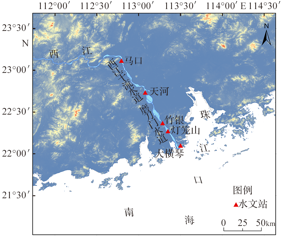
图1 研究区及测站
Fig.1 The study area and stations
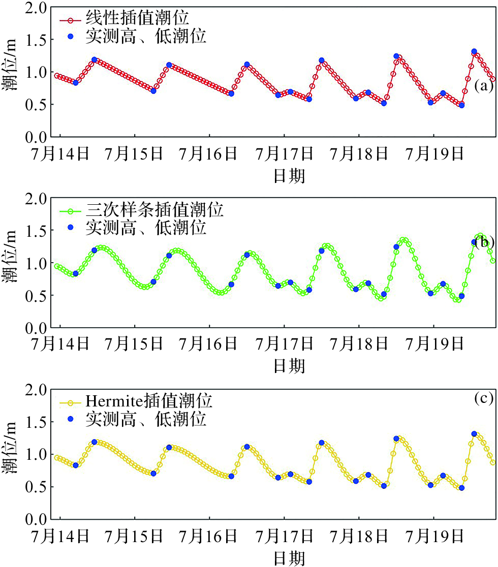
图2 三种插值方法结果比较(2016年,马口站)
Fig.2 Result comparison of three interpolation methods (2016, Makou Station)
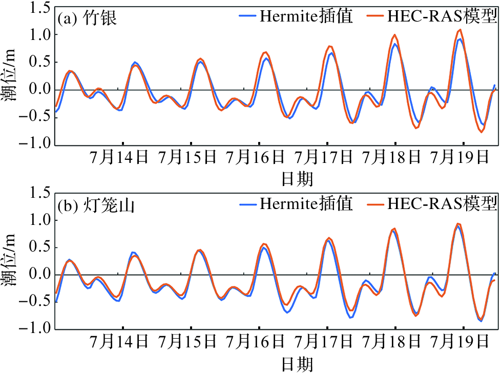
图3 Hermite插值潮位与HEC-RAS模拟潮位的对比 ( 2016年)
Fig.3 Comparison between Hermite interpolated tide levels and simulated tide levels of the HEC-RAS model in 2016
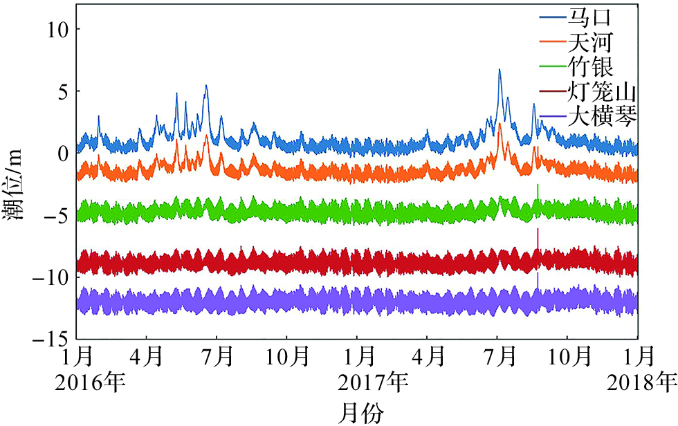
图4 2016—2017年西江感潮河段沿程测站潮位变化
Fig.4 Changes in tide levels at stations along the tidal reach of Xijiang River in 2016-2017

图5 调和分析边界条件
Fig.5 Boundary conditions for harmonic analysis
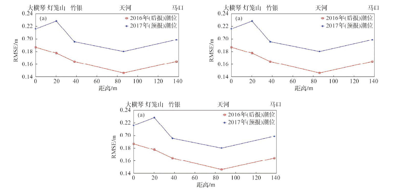
图6 西江感潮河段各测站潮位验证
Fig.6 Verification of tide level at each station along the tidal reach of Xijiang River
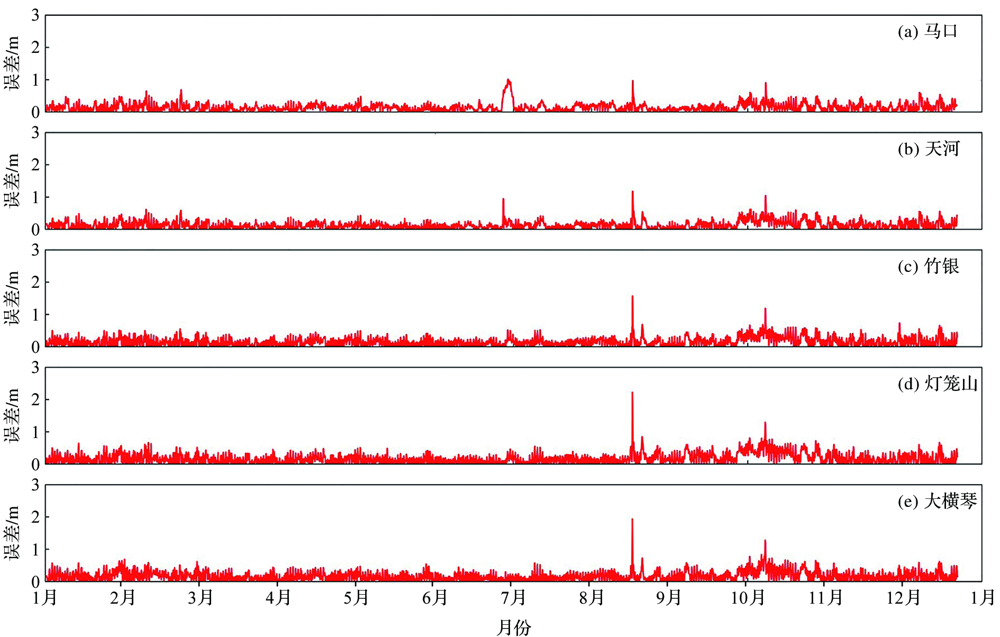
图7 2017年西江感潮河段各测站潮位预报误差
Fig.7 Forecast errors of tidal level of each station in the tidal reach of Xijiang River in 2017

图8 台风影响下灯笼山(a)和洪水影响下马口(b)的潮位预报误差(2017年)
Fig.8 Forecast error of tidal level at Denglongshan (a) under typhoon and Makou (b) under flood (2017)
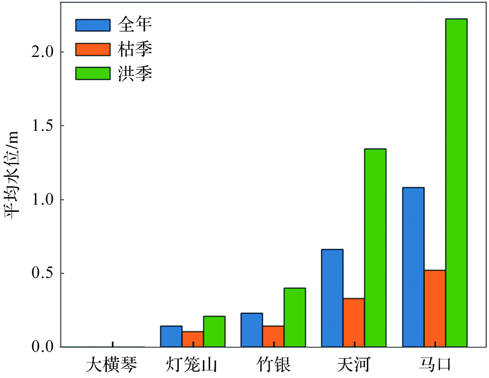
图9 2016年西江感潮河段各站平均水位
Fig.9 Mean water level at each station along the tidal reach of Xijiang River in 2016

图10 西江感潮河段各站分潮振幅变化
Fig.10 Amplitude variation of the tide at each station along the tidal reach of Xijiang River
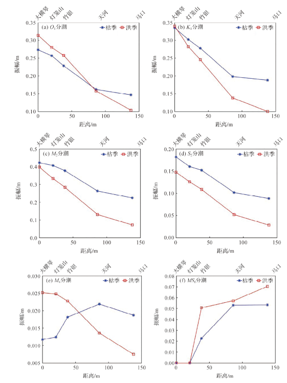
图11 西江感潮河段沿程各站分潮振幅洪、枯季变化
Fig.11 Changes of tidal amplitude in wet and dry seasons at each station along the tidal reach of Xijiang River
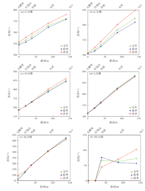
图12 西江感潮河段沿程各站分潮迟角变化
Fig.12 Changes of tidal phase at each station along the tidal reach of Xijiang River
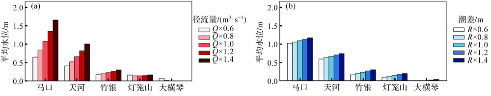
图13 西江感潮河段沿程各站平均水位对径流(a)和潮差(b)的响应
Fig.13 Response of the mean water level to river discharge (a) and tidal range (b) at each station along the tidal reach of Xijiang River

图14 西江感潮河段沿程各站不同分潮的振幅对径流和潮差的响应
Fig.14 Response of the tidal amplitudes to river discharge and tidal range at each stations along the tidal reach of Xijiang River
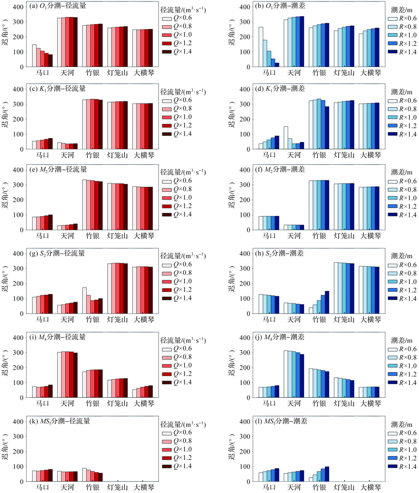
图15 西江感潮河段沿程各站不同分潮迟角对径流和潮差的响应
Fig.15 Response of the tidal phases to river discharge and tidal range at each stations along the tidal reach of Xijiang River
| [1] | FOREMAN M G G, HENRY R F. Tidal analysis based on high and low water observations[M]. Institute of Ocean Sciences, Patricia Bay, 1979. |
| [2] | 戴荣, 徐俊. 基于高低潮分析的天文潮推算[J]. 西北水电, 2011(2):8-10. |
| DAI R, XU J. Astronomical tide calculation based on analysis of low and high tides[J]. Northwest Hydropower, 2011(2): 8-10. | |
| [3] | LUO X Y, ZHANG W, CHEN S J, et al. Evolution of reversal of the lowest low waters in a tidal river network[J]. Journal of Hydrology, 2020, 585: 124701. |
| [4] | 李阳东, 李仁虎, 常亮. 基于高、低潮的潮汐调和常数提取及潮汐预报[J]. 海洋湖沼通报, 2020(2):55-63. |
| LI Y D, LI R H, CHANG L. Tidal harmonic constants extraction and tidal prediction based on high and low tidal waters[J]. Transactions of Oceanology and Limnology, 2020(2): 55-63. | |
| [5] | 王如云, 占飞, 周钧, 等. 基于高低潮的优化保形调和分析模型(OCTHM)及算法[J]. 水运工程, 2014(8):15-19. |
| WANG R Y, ZHAN F, ZHOU J, et al. Optimizing conformal tidal harmonic analysis model(OCTHM) and algorithm based on high & low water observations[J]. Port & Waterway Engineering, 2014(8): 15-19. | |
| [6] | 刘娇, 史国友, 朱凯歌, 等. 基于调和分析和ARIMA-SVR的组合潮汐预测模型[J]. 上海海事大学学报, 2019, 40(3):93-99. |
| LIU J, SHI G Y, ZHU K G, et al. A combined tide prediction model based on harmonic analysis and ARIMA-SVR[J]. Journal of Shanghai Maritime University, 2019, 40(3): 93-99. | |
| [7] | 蔡松, 叶瑞明, 王齐林, 等. 基于无为原理的潮汐分析与预测[J]. 海洋测绘, 2021, 41(3):47-51. |
| CAI S, YE R M, WANG Q L, et al. Tide analysis and prediction based on inaction principle[J]. Hydrographic Surveying and Charting, 2021, 41(3): 47-51. | |
| [8] | 王长海. 潮汐调和分析的一种模式[J]. 海洋预报, 1995, 12(4):71-76. |
| WANG C H. A model of tidal harmonic analysis[J]. Marine Forecasts, 1995, 12(4):71-76. | |
| [9] | MATTE P, JAY D A, ZARON E D. Adaptation of classical tidal harmonic analysis to nonstationary tides, with application to river tides[J]. Journal of Atmospheric and Oceanic Technology, 2013, 30(3): 569-589. |
| [10] | PAN H D, LÜ X Q, WANG Y Y, et al. Exploration of tidal-fluvial interaction in the Columbia River Estuary using S_TIDE[J]. Journal of Geophysical Research: Oceans, 2018, 123(9): 6598-6619. |
| [11] | PAWLOWICZ R, BEARDSLEY B, LENTZ S. Classical tidal harmonic analysis including error estimates in MATLAB using T_TIDE[J]. Computers & Geosciences, 2002, 28(8): 929-937. |
| [12] | MATTE P, SECRETAN Y, MORIN J. Temporal and spatial variability of tidal-fluvial dynamics in the St. Lawrence fluvial estuary: An application of nonstationary tidal harmonic analysis[J]. Journal of Geophysical Research: Oceans, 2014, 119(9): 5724-5744. |
| [13] | 吕咸青, 潘海东, 王雨哲. 潮汐调和分析方法的回顾与展望[J]. 海洋科学, 2021, 45(11):132-143. |
| LÜ X Q, PAN H D, WANG Y Z. Review and prospect of tidal harmonic analysis method[J]. Marine Sciences, 2021, 45(11): 132-143. | |
| [14] | KUKULKA T, JAY D A. Impacts of Columbia River discharge on salmonid habitat: 1. A nonstationary fluvial tide model[J]. Journal of Geophysical Research: Oceans, 2003, 108(C9): 3293. |
| [15] | KUKULKA T, JAY D A. Impacts of Columbia River discharge on salmonid habitat: 2. Changes in shallow-water habitat[J]. Journal of Geophysical Research: Oceans, 2003, 108(C9): 3294. |
| [16] | JAY D A, FLINCHEM E P. A comparison of methods for analysis of tidal records containing multi-scale non-tidal background energy[J]. Continental Shelf Research, 1999, 19(13): 1695-1732. |
| [17] | 江海东, 费岳军, 应岳. 使用MATLAB拟合工具箱进行潮汐调和分析[J]. 海洋技术, 2012, 31(3):33-36. |
| JIANG H D, FEI Y J, YING Y. Tidal harmonic analysis using the MATLAB fitting toolbox[J]. Ocean Technology, 2012, 31(3): 33-36. | |
| [18] | 李大炜, 李建成, 团文征. 越南沿海若干验潮站长期观测资料的潮汐分析[J]. 海洋测绘, 2017, 37(3):29-31,52. |
| LI D W, LI J C, TUAN W Z. Tidal analysis of long-term observation data of tide gauges along Vietnam coast[J]. Hydrographic Surveying and Charting, 2017, 37(3): 29-31, 52. | |
| [19] | 宋艳朋, 周兴华, 付延光, 等. Matlab.NET混合编程在潮汐调和分析与预报中的应用[J]. 测绘与空间地理信息, 2017, 40(5):59-61,64. |
| SONG Y P, ZHOU X H, FU Y G, et al. The application of integrated programming technology of Matlab.NET in tidal harmonic analysis and prediction[J]. Geomatics & Spatial Information Technology, 2017, 40(5): 59-61, 64. | |
| [20] | GAN M, CHEN Y P, PAN S Q, et al. A modified nonstationary tidal harmonic analysis model for the Yangtze estuarine tides[J]. Journal of Atmospheric and Oceanic Technology, 2019, 36(4): 513-525. |
| [21] | YU X Y, ZHANG W, HOITINK A J F. Impact of river discharge seasonality change on tidal duration asymmetry in the Yangtze River Estuary[J]. Scientific Reports, 2020, 10: 6304. |
| [22] | 蔡华阳, 杨昊, 郭晓娟, 等. 珠江磨刀门河口径潮动力耦合条件下余水位的多时空尺度分析[J]. 海洋学报, 2018, 40(7):55-65. |
| CAI H Y, YANG H, GUO X J, et al. Investigation of temporal-spatial distribution patterns of residual water level under the influence of tide-river interaction in the Modaomen Estuary, Zhujiang River[J]. Haiyang Xuebao, 2018, 40(7): 55-65. | |
| [23] | 唐启邦, 欧素英, 蔡华阳, 等. 珠江磨刀门河口水位与海平面、上游流量的联合分布关系异变研究[J]. 海洋与湖沼, 2020, 51(5):1080-1092. |
| TANG Q B, OU S Y, CAI H Y, et al. Abrupt variation of joint distibution of water level, sea level, and river discharge in the Modaomen estuary of the Zhujiang(Pearl) River[J]. Oceanologia et Limnologia Sinica, 2020, 51(5): 1080-1092. | |
| [24] | 张先毅, 杨昊, 黄竞争, 等. 强人类活动驱动下珠江磨刀门河口径潮动力的季节性异变特征[J]. 海洋与湖沼, 2020, 51(5):1043-1054. |
| ZHANG X Y, YANG H, HUANG J Z, et al. Impact of intensive human activity on seasonal variation in river-tide dynamics in the Modaomen estuary of Zhujiang (Pearl) River[J]. Oceanologia et Limnologia Sinica, 2020, 51(5): 1043-1054. | |
| [25] | 钟子悦, 余明辉, 陈小齐, 等. 珠江三角洲河网地形和径流条件变化对潮动力格局的影响[J]. 水资源保护, 2023, 39(3):213-221. |
| ZHONG Z Y, YU M H, CHEN X Q, et al. Effects of changes in river network topography and runoff on tidal dynamic pattern in Pearl River Delta[J]. Water Resources Protection, 2023, 39(3): 213-221. | |
| [26] | 邱秀芳, 李博, 王博芝, 等. 珠江河网典型横向汊道径潮动力时空差异性分析:以“南沙—南华” 横向汊道为例[J]. 热带海洋学报, 2023, 42(4):77-90. |
| QIU X F, LI B, WANG B Z, et al. Spatial-temporal variations in tide-river dynamics of typical transverse channel in the Pearl River channel networks—Taking the ‘Nansha-Nanhua’ transverse channel as an example[J]. Journal of Tropical Oceanography, 2023, 42(4): 77-90. | |
| [27] | 蒋陈娟, 周佳楠, 杨清书. 珠江磨刀门河口潮汐动力变化对人类活动的响应[J]. 热带海洋学报, 2020, 39(6):66-76. |
| JIANG C J, ZHOU J N, YANG Q S. Effects of human intervention on tidal dynamics in the Modaomen Estuary, Pearl River[J]. Journal of Tropical Oceanography, 2020, 39(6): 66-76. | |
| [28] | 武家兴, 张卓, 陈鹏, 等. 考虑流量变化影响的西江感潮河道潮汐特征分析[J]. 海洋学报, 2023, 45(7):8-24. |
| WU J X, ZHANG Z, CHEN P, et al. Analysis of the tidal characteristics along the tidal reach of Xijiang River considering river discharge variation[J]. Haiyang Xuebao, 2023, 45(7): 8-24. | |
| [29] | 武家兴, 王浩丞, 张璐, 等. 西江感潮河道(马口—磨刀门)的潮波传播特征研究[J]. 热带海洋学报, 2023, 42(4):47-62. |
| WU J X, WANG H C, ZHANG L, et al. Investigation into the tidal propagation features along the tidal reach of the West River (Makou—Modaomen)[J]. Journal of Tropical Oceanography, 2023, 42(4): 47-62. | |
| [30] | 中华人民共和国水利部. 珠江流域水文资料第8卷第7册珠江三角洲河口区(二)[G]. 2017. |
| Ministry of Water Resources of the People’s Republic of China. Hydrological data of the Pearl River basin volume 8, book 7: Pearl River delta estuary area (II)[G]. 2017. | |
| [31] | 刘田甲. 潮汐数据插值方法研究[D]. 南京: 南京师范大学, 2017. |
| LIU T J. Research on interpolation method of tidal data[D]. Nanjing: Nanjing Normal University, 2017. | |
| [32] | 乔光全, 徐润刚, 卢永昌, 等. 高低潮位扩展至逐时潮位的插值方法比较[J]. 水运工程, 2019(9):6-12. |
| QIAO G Q, XU R G, LU Y C, et al. Comparison of interpolation method for high and low tidal lever extending to hourly data[J]. Port & Waterway Engineering, 2019(9): 6-12. | |
| [33] | WONG L A, CHEN J C, XUE H, et al. A model study of the circulation in the Pearl River Estuary (PRE) and its adjacent coastal waters: 1. Simulations and comparison with observations[J]. Journal of Geophysical Research: Oceans, 2003, 108(C5): 3156. |
| [34] | 马玉婷, 蔡华阳, 杨昊, 等. 珠江磨刀门河口水位分布演变特征及其对人类活动的响应[J]. 热带海洋学报, 2022, 41(2):52-64. |
| MA Y T, CAI H Y, YANG H, et al. Evolution of water level profile dynamics in the Modaomen Estuary of the Pearl River and its responses to human activities[J]. Journal of Tropical Oceanography, 2022, 41(2): 52-64. | |
| [35] | HOITINK A J F, JAY D A. Tidal river dynamics: Implications for deltas[J]. Reviews of Geophysics, 2016, 54(1): 240-272. |
| [36] | JAY D A, LEFFLER K, DIEFENDERFER H L, et al. Tidal-fluvial and estuarine processes in the lower Columbia River: I. Along-channel water level variations, Pacific Ocean to Bonneville Dam[J]. Estuaries and Coasts, 2015, 38(2): 415-433. |
| [37] | BUSCHMAN F A, HOITINK A J F, VAN DER VEGT M, et al. Subtidal water level variation controlled by river flow and tides[J]. Water Resources Research, 2009, 45(10): W10420. |
| [38] | SASSI M G, HOITINK A J F. River flow controls on tides and tide-mean water level profiles in a tidal freshwater river[J]. Journal of Geophysical Research: Oceans, 2013, 118(9): 4139-4151. |
| [1] | 张安民, 宁一伟, 王晨旭, 张豪, 刘荣霞, 孙朝辉. 天津港主航道连续观测点潮流和余流特征分析[J]. 海洋学研究, 2019, 37(1): 75-82. |
| [2] | 刘洪博, 潘国富, 应元康, 黄潘阳, 胡涛骏. 基于海洋潮汐动力模型的水位改正方法研究[J]. 海洋学研究, 2014, 32(2): 35-39. |
| [3] | 田志光, 杨春辉, 王振峰. 东海北部1个潜标连续观测站的潮流垂向特征分析[J]. 海洋学研究, 2014, 32(2): 40-45. |
| [4] | 师鹏飞, 许东峰, 王俊, 徐鸣泉. 三门湾外海的潮汐和潮流特征[J]. 海洋学研究, 2012, 30(2): 27-35. |
| 阅读次数 | ||||||
|
全文 |
|
|||||
|
摘要 |
|
|||||