海洋学研究 ›› 2024, Vol. 42 ›› Issue (1): 69-82.DOI: 10.3969/j.issn.1001-909X.2024.01.007
基于遥感数据与数值模式的浒苔漂移输运预报:以江苏近海为例
林连杰1( ), 董昌明1,*(), 嵇宇翔2, LIM KAM SIAN Kenny Thiam Choy3, 李兆鑫4, 蒋星亮5, 曹玉晗6, 高慧1, 王胜强1, 曹茜1
- 1.南京信息工程大学 海洋科学学院,江苏 南京 210044
2.江苏省连云港市气象局,江苏 连云港 222006
3.无锡学院,江苏 无锡 214105
4.华东师范大学 河口海岸学国家重点实验室,上海 200241
5.复旦大学 大气与海洋科学系,上海 200433
6.江苏海洋大学 海洋技术与测绘学院,江苏 连云港 222005
-
收稿日期:2023-03-15修回日期:2023-09-08出版日期:2024-03-15发布日期:2024-05-11 -
通讯作者:* 董昌明(1974—),男,教授,主要从事物理海洋学、海洋数值模拟、人工智能海洋学及实验地球流体力学等方面的研究,E-mail:002537@nuist.edu.cn。 -
作者简介:林连杰(1998—),男,福建省泉州市人,主要从事海洋气象及数值模拟等方面的研究,E-mail:20211209005@nuist.edu.cn。 -
基金资助:江苏省研究生科研与实践创新计划项目(KYCX23_1346);江苏省自然资源发展专项资金项目(JSZRHYKJ202102);国家自然科学基金项目(42130405)
Prediction of UIva prolifera drift and transportation based on remote sensing data and numerical models: A case study in the offshore area of Jiangsu Province
LIN Lianjie1(), DONG Changming1,*(), JI Yuxiang2, LIM KAM SIAN Kenny Thiam Choy3, LI Zhaoxin4, JIANG Xingliang5, CAO Yuhan6, GAO Hui1, WANG Shengqiang1, CAO Qian1
- 1. School of Marine Sciences, Nanjing University of Information Science and Technology, Nanjing 210044, China
2. Lianyungang Meteorological Bureau of Jiangsu Province, Lianyungang 222006, China
3. Wuxi University, Wuxi 214105, China
4. State Key Laboratory of Estuarine and Coastal Sciences, East China Normal University, Shanghai 200241, China
5. Department of Atmospheric and Oceanic Sciences, Fudan University, Shanghai 200433, China
6. School of Marine Technology and Geomatics, Jiangsu Ocean University, Lianyungang 222005, China
-
Received:2023-03-15Revised:2023-09-08Online:2024-03-15Published:2024-05-11
摘要:
浒苔暴发是影响全球近岸海域最为严重的海洋灾害之一,引起了社会各方的重视。该研究基于大气-波浪-海洋集合模式,根据卫星遥感数据提取浒苔位置,采用拉格朗日漂流模式对浒苔进行追踪并预报其漂移路径。与卫星观测结果对比表明,该集合模式能够较好地预报浒苔的位置、分布及其漂移路径。此外,该研究还讨论了Stokes漂流对于模式预报的影响,结果表明考虑Stokes漂流可以修正浒苔漂移路径,有效提高预报的准确性。
中图分类号:
引用本文
林连杰, 董昌明, 嵇宇翔, LIM KAM SIAN Kenny Thiam Choy, 李兆鑫, 蒋星亮, 曹玉晗, 高慧, 王胜强, 曹茜. 基于遥感数据与数值模式的浒苔漂移输运预报:以江苏近海为例[J]. 海洋学研究, 2024, 42(1): 69-82.
LIN Lianjie, DONG Changming, JI Yuxiang, LIM KAM SIAN Kenny Thiam Choy, LI Zhaoxin, JIANG Xingliang, CAO Yuhan, GAO Hui, WANG Shengqiang, CAO Qian. Prediction of UIva prolifera drift and transportation based on remote sensing data and numerical models: A case study in the offshore area of Jiangsu Province[J]. Journal of Marine Sciences, 2024, 42(1): 69-82.
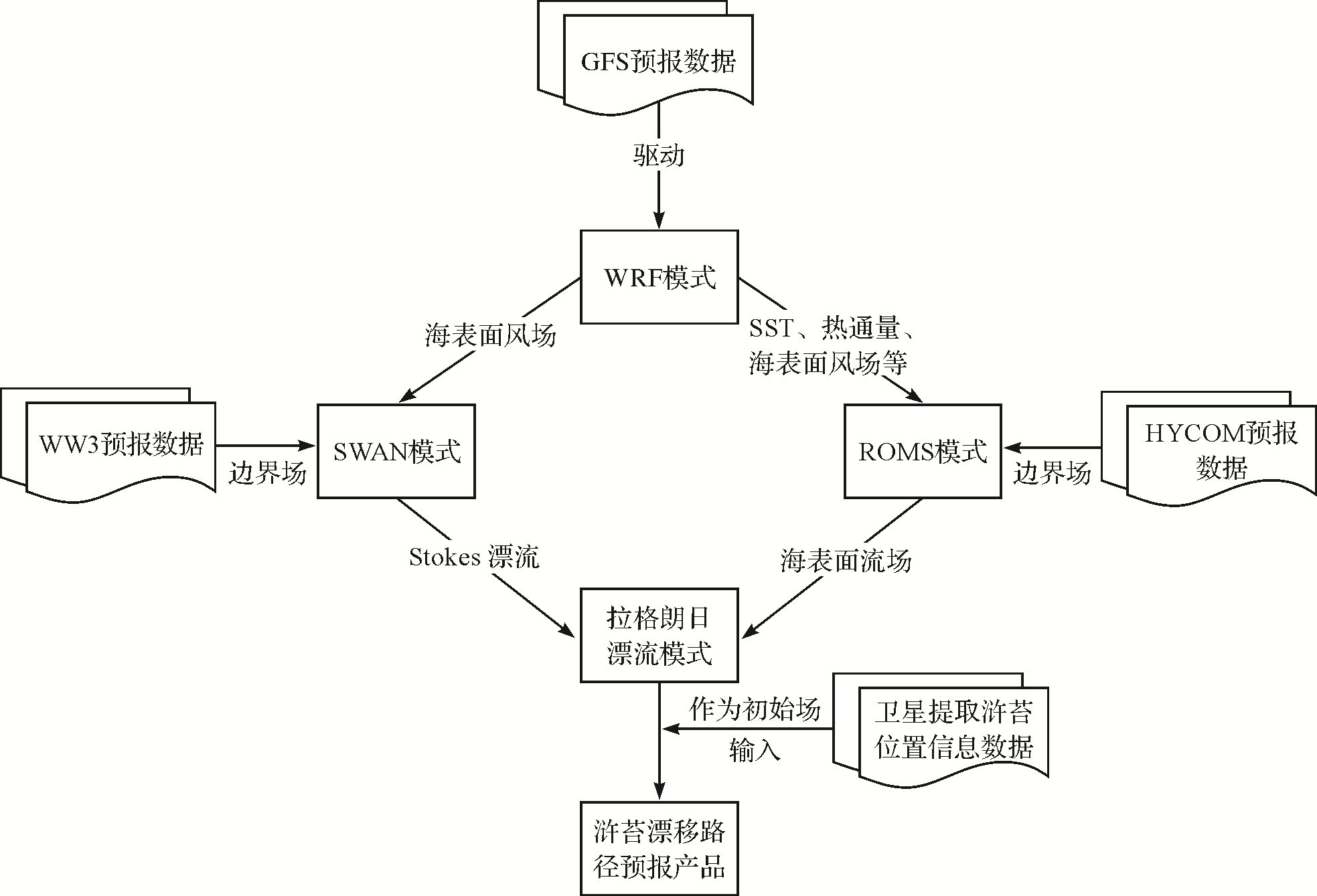
图1 江苏近海浒苔预报模式流程示意图
Fig.1 Schematic diagram of the forecast model process of UIva prolifera in Jiangsu offshore
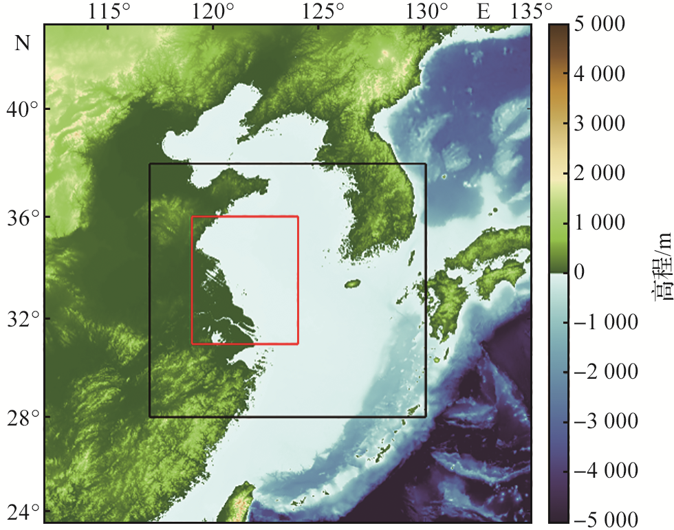
图2 WRF模式范围设置示意图 (黑色框区域为WRF模式的计算范围,红色框区域为浒苔预报范围。)
Fig.2 Diagram of WRF model range setting (The black box area is the calculation range of WRF model, and the red box area is the UIva prolifera forecast range.)
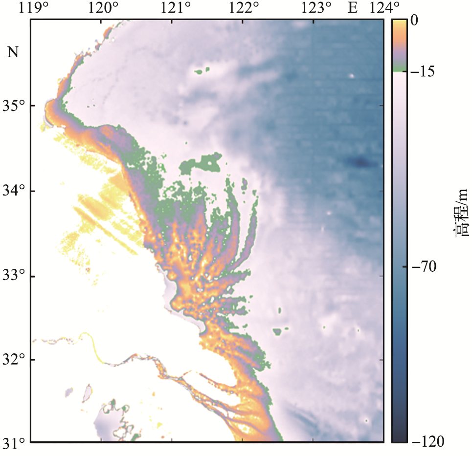
图3 ROMS模式地形图
Fig.3 Topographic map of ROMS model
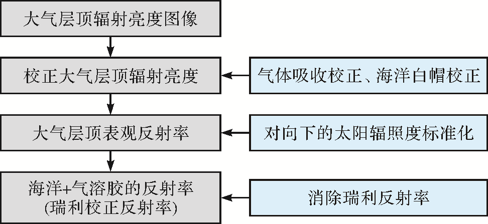
图4 GOCI数据预处理流程图
Fig.4 Flow chart of GOCI data preprocessing
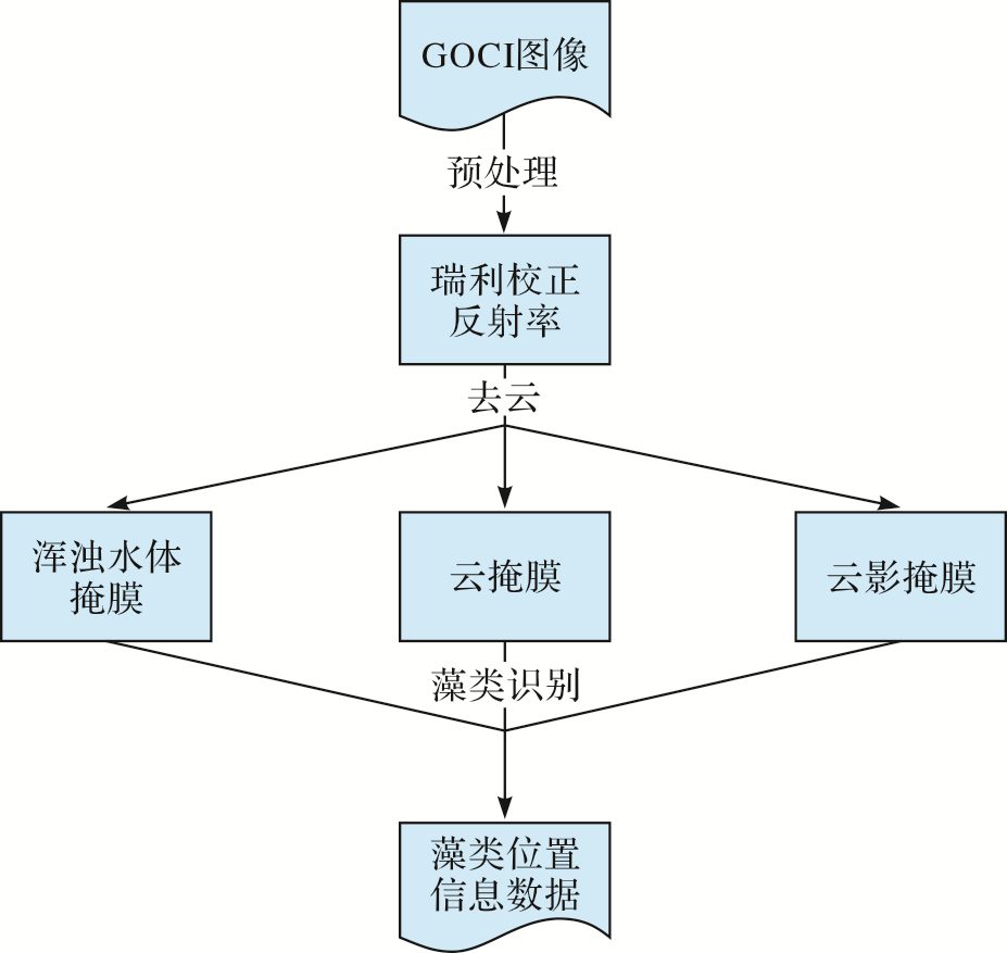
图5 藻类位置信息数据处理流程图
Fig.5 Flow chart of algae location information data processing
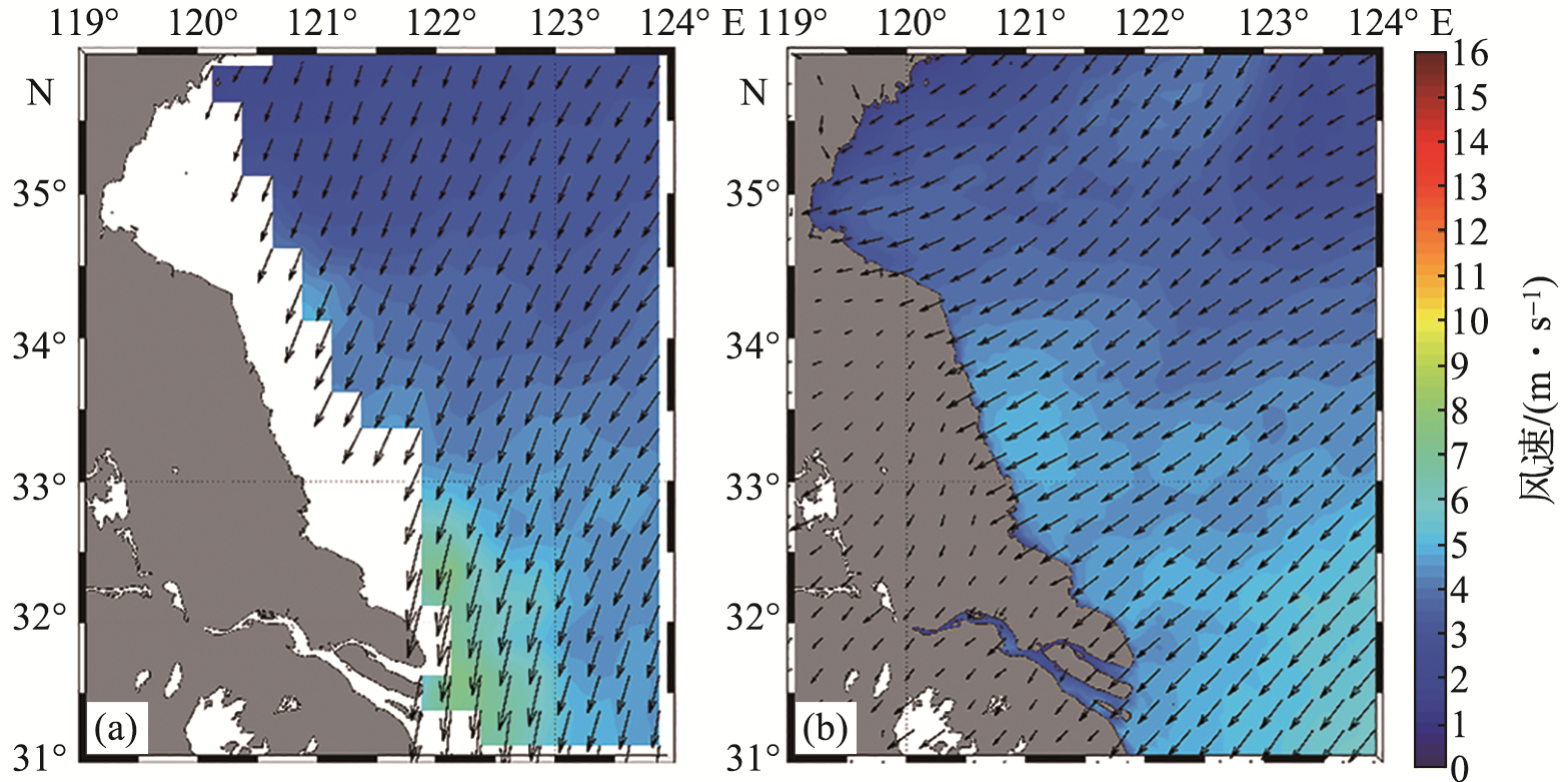
图6 ASCAT观测的(a)和WRF模式模拟的(b)2019年9月研究区海面10 m风速月平均数据对比
Fig.6 Comparison between ASCAT observation (a) and WRF model simulation (b) in monthly average sea surface wind speed data at 10 meters in the study area in September 2019

图7 ASCAT观测的和WRF模式模拟的2019年9月研究区月平均海面10 m风速相对误差空间分布
Fig.7 Spatial distribution of relative errors in monthly average sea surface wind speed data at 10 meters observed by ASCAT and simulated by WRF model in the study area in September 2019
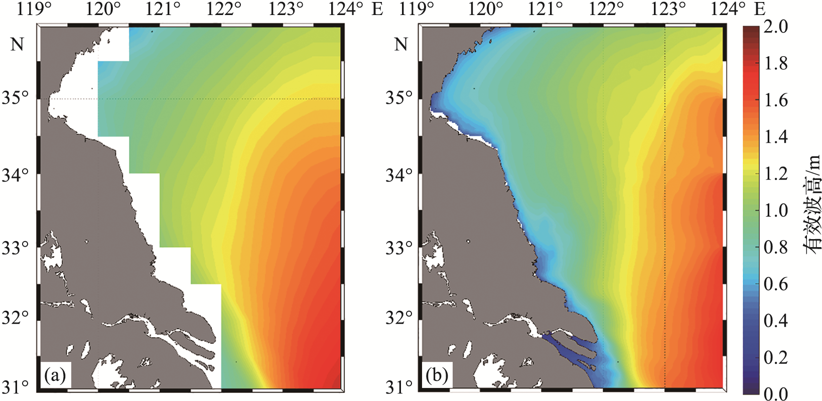
图8 ERA5(a)和SWAN模式(b)模拟的2019年9月研究区月平均有效波高对比
Fig.8 Comparison the of monthly average significant wave heights simulated by ERA5 (a) and SWAN model (b) in the study area in September 2019

图9 ERA5和SWAN模式模拟的2019年9月研究区月平均有效波高相对误差空间分布
Fig.9 Spatial distribution of relative errors in monthly average significant wave height simulated by ERA5 and SWAN modes in the study area in September 2019
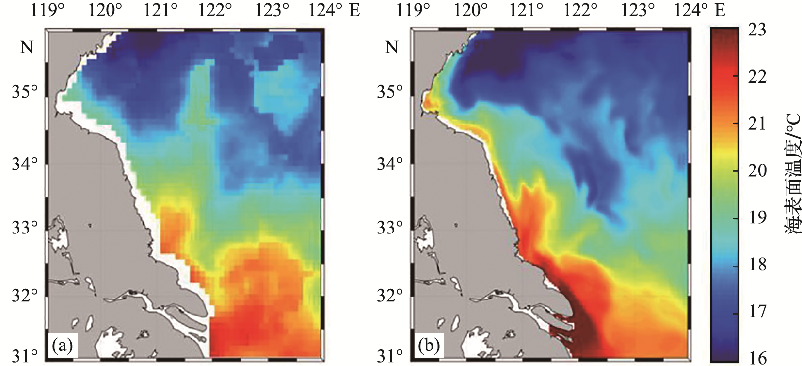
图10 RSS提供的卫星观测的(a)和ROMS模式模拟的(b) 2019年6月研究区海表面温度对比
Fig.10 Comparison of sea surface temperature between satellite observation provided by RSS (a) and simulated by ROMS model (b) in the study area in June 2019
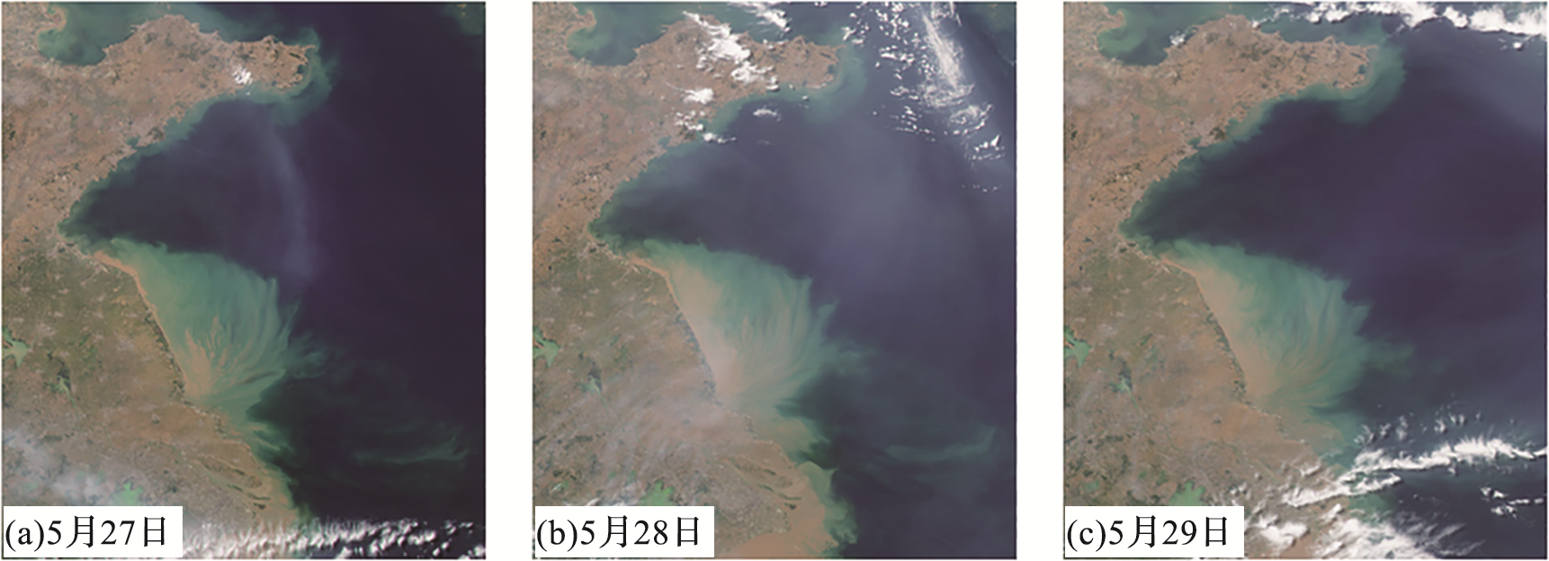
图11 2017年5月27日—29日卫星遥感观测影像
Fig.11 Satellite remote sensing observation images on May 27th-29th, 2017

图12 2017年5月27日与28日模式预报的浒苔覆盖区域与卫星观测结果对比 (虚框表示浒苔出现区块。)
Fig.12 Comparison of the coverage area of UIva prolifera predicted by the model and satellite observations on May 27th and 28th, 2017 (The dashed box represents the appearance block of UIva prolifera.)
| 区域 | 浒苔覆盖面积 | 浒苔中心点位置 | |||||
|---|---|---|---|---|---|---|---|
| 卫星观测/km2 | 模式预报/km2 | 误差/% | 卫星观测 | 模式预报 | 误差/km | ||
| 连云港近岸 | 38.89 | 31.56 | 23.20 | 34.88 °N,119.25 °E | 34.89 °N,119.24 °E | 0.01 | |
| 黄海北部离岸 | 975.17 | 1 170.60 | 16.70 | 35.01 °N,121.41 °E | 34.87 °N,121.23 °E | 0.28 | |
| 长江口 | 133.82 | 166.23 | 19.50 | 31.48 °N,121.93 °E | 31.64 °N,121.86 °E | 0.28 | |
| 江苏近海 | 1 147.88 | 1 368.39 | 16.11 | ||||
表1 48 h模式预报与卫星观测的浒苔覆盖面积及中心点位置(2017年5月27日与28日的平均值)
Tab.1 48-hour model prediction and satellite observation of the coverage area and center point position of UIva prolifera (average values of May 27th and 28th, 2017)
| 区域 | 浒苔覆盖面积 | 浒苔中心点位置 | |||||
|---|---|---|---|---|---|---|---|
| 卫星观测/km2 | 模式预报/km2 | 误差/% | 卫星观测 | 模式预报 | 误差/km | ||
| 连云港近岸 | 38.89 | 31.56 | 23.20 | 34.88 °N,119.25 °E | 34.89 °N,119.24 °E | 0.01 | |
| 黄海北部离岸 | 975.17 | 1 170.60 | 16.70 | 35.01 °N,121.41 °E | 34.87 °N,121.23 °E | 0.28 | |
| 长江口 | 133.82 | 166.23 | 19.50 | 31.48 °N,121.93 °E | 31.64 °N,121.86 °E | 0.28 | |
| 江苏近海 | 1 147.88 | 1 368.39 | 16.11 | ||||
| 区域 | 5月27日浒苔漂移方向/(°) | 5月28日浒苔漂移方向/(°) | |||||
|---|---|---|---|---|---|---|---|
| 卫星观测 | 模式预报 | 误差 | 卫星观测 | 模式预报 | 误差 | ||
| 连云港近岸 | 275.49 | 214.42 | 61.07 | 88.85 | 52.59 | 36.26 | |
| 黄海北部离岸 | 39.88 | 48.84 | -8.96 | 33.60 | 137.89 | -104.29 | |
| 长江口 | 294.16 | 334.53 | -40.37 | 95.58 | 86.68 | 8.90 | |
表2 48 h模式预报与卫星观测的浒苔漂移方向(2017年5月27日和28日)
Tab.2 48-hour model prediction and satellite observation of the drift direction of UIva prolifera (May 27th and 28th, 2017)
| 区域 | 5月27日浒苔漂移方向/(°) | 5月28日浒苔漂移方向/(°) | |||||
|---|---|---|---|---|---|---|---|
| 卫星观测 | 模式预报 | 误差 | 卫星观测 | 模式预报 | 误差 | ||
| 连云港近岸 | 275.49 | 214.42 | 61.07 | 88.85 | 52.59 | 36.26 | |
| 黄海北部离岸 | 39.88 | 48.84 | -8.96 | 33.60 | 137.89 | -104.29 | |
| 长江口 | 294.16 | 334.53 | -40.37 | 95.58 | 86.68 | 8.90 | |

图13 2017年6月16日—18日卫星遥感观测影像
Fig.13 Satellite remote sensing observation images on June 16th-18th, 2017
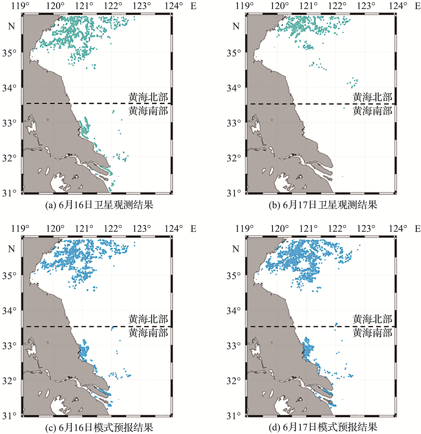
图14 2017年6月16日与17日模式预报的浒苔覆盖区域与卫星观测结果对比
Fig.14 Comparison of the coverage area of UIva prolifera predicted by the model and satellite observations on June 16th and 17th, 2017
| 区域 | 浒苔覆盖面积 | 浒苔中心点位置 | |||||
|---|---|---|---|---|---|---|---|
| 卫星观测/km2 | 模式预报/km2 | 误差/% | 卫星观测 | 模式预报 | 误差/km | ||
| 黄海北部 | 1 270.30 | 1 212.00 | 4.81 | 35.61°N,120.85°E | 34.88°N,121.17°E | 1.20 | |
| 黄海南部 | 440.61 | 155.71 | 182.97 | 32.89°N,122.84°E | 31.62°N,121.85°E | 2.04 | |
| 江苏近海 | 1 710.91 | 1 367.71 | 25.09 | ||||
表3 48 h模式预报与卫星观测的浒苔覆盖面积及中心点位置(2017年6月16日和17日的平均值)
Tab.3 48-hour model prediction and satellite observation of the coverage area and center point position of UIva prolifera (average values of June 16th and 17th, 2017)
| 区域 | 浒苔覆盖面积 | 浒苔中心点位置 | |||||
|---|---|---|---|---|---|---|---|
| 卫星观测/km2 | 模式预报/km2 | 误差/% | 卫星观测 | 模式预报 | 误差/km | ||
| 黄海北部 | 1 270.30 | 1 212.00 | 4.81 | 35.61°N,120.85°E | 34.88°N,121.17°E | 1.20 | |
| 黄海南部 | 440.61 | 155.71 | 182.97 | 32.89°N,122.84°E | 31.62°N,121.85°E | 2.04 | |
| 江苏近海 | 1 710.91 | 1 367.71 | 25.09 | ||||
| 区域 | 6月16日浒苔漂移方向/(°) | 6月17日浒苔漂移方向/(°) | |||||
|---|---|---|---|---|---|---|---|
| 卫星观测 | 模式预报 | 误差 | 卫星观测 | 模式预报 | 误差 | ||
| 黄海北部 | 58.61 | 66.13 | -7.52 | 47.53 | 126.43 | -78.90 | |
| 黄海南部 | 229.13 | 224.27 | 4.86 | 48.73 | 268.99 | -220.26 | |
表4 48 h模式预报与卫星观测的浒苔漂移方向(2017年6月16日和17日)
Tab.4 48-hour model prediction and satellite observation of the drift direction of UIva prolifera (June 16th and 17th, 2017)
| 区域 | 6月16日浒苔漂移方向/(°) | 6月17日浒苔漂移方向/(°) | |||||
|---|---|---|---|---|---|---|---|
| 卫星观测 | 模式预报 | 误差 | 卫星观测 | 模式预报 | 误差 | ||
| 黄海北部 | 58.61 | 66.13 | -7.52 | 47.53 | 126.43 | -78.90 | |
| 黄海南部 | 229.13 | 224.27 | 4.86 | 48.73 | 268.99 | -220.26 | |
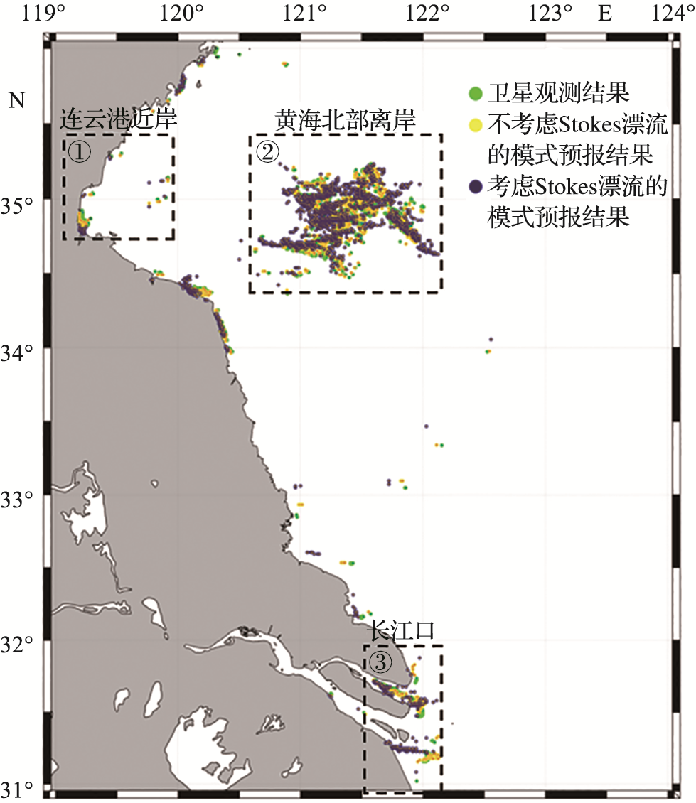
图15 考虑Stokes漂流模式和不考虑Stokes漂流模式24 h预报的浒苔分布与卫星观测结果的对比(2017年5月27日)
Fig.15 Comparison between the distribution of UIva prolifera predicted by the 24-hour forecast considering and without considering the Stokes Drift model and the satellite observation results (May 27th, 2017)
| 区域 | 浒苔覆盖面积/km2 | 模式预报浒苔覆盖面积与卫星观测结果的误差/% | ||||
|---|---|---|---|---|---|---|
| 卫星观测 | 考虑Stokes漂流模式 | 不考虑Stokes漂流模式 | 考虑Stokes漂流模式 | 不考虑Stokes漂流模式 | ||
| 连云港近岸 | 34.34 | 32.26 | 26.65 | 0.06 | 28.84 | |
| 黄海北部离岸 | 1 029.70 | 1 200.77 | 1 474.32 | 14.25 | 30.16 | |
| 长江口 | 143.42 | 175.35 | 200.60 | 18.21 | 28.50 | |
| 江苏近海 | 1 207.46 | 1 408.38 | 1 701.57 | 14.27 | 29.04 | |
表5 考虑Stokes漂流模式和不考虑Stokes漂流模式预报的24 h浒苔覆盖面积与卫星观测结果对比(2017年5月27日)
Tab.5 Comparison of 24-hour UIva prolifera coverage area predicted by considering and without considering the Stokes Drift model with satellite observation results (May 27th, 2017)
| 区域 | 浒苔覆盖面积/km2 | 模式预报浒苔覆盖面积与卫星观测结果的误差/% | ||||
|---|---|---|---|---|---|---|
| 卫星观测 | 考虑Stokes漂流模式 | 不考虑Stokes漂流模式 | 考虑Stokes漂流模式 | 不考虑Stokes漂流模式 | ||
| 连云港近岸 | 34.34 | 32.26 | 26.65 | 0.06 | 28.84 | |
| 黄海北部离岸 | 1 029.70 | 1 200.77 | 1 474.32 | 14.25 | 30.16 | |
| 长江口 | 143.42 | 175.35 | 200.60 | 18.21 | 28.50 | |
| 江苏近海 | 1 207.46 | 1 408.38 | 1 701.57 | 14.27 | 29.04 | |
| 区域 | 浒苔中心点位置 | 模式预报浒苔中心点位置与卫星观测结果的误差/km | ||||
|---|---|---|---|---|---|---|
| 卫星观测 | 考虑Stokes漂流模式 | 不考虑Stokes漂流模式 | 考虑Stokes漂流模式 | 不考虑Stokes漂流模式 | ||
| 连云港近岸 | 34.87°N,119.25°E | 34.87°N,119.24°E | 34.88°N,119.23°E | 0.01 | 0.02 | |
| 黄海北部离岸 | 34.96°N,121.34°E | 34.86°N,121.23°E | 34.86°N,121.24°E | 0.19 | 0.19 | |
| 长江口 | 31.45°N,121.93°E | 31.64°N,121.76°E | 31.63°N,121.86°E | 0.38 | 0.32 | |
表6 考虑Stokes漂流模式和不考虑Stokes漂流模式预报的24 h浒苔中心点位置与卫星观测结果对比(2017年5月27日)
Tab.6 Comparison of the 24-hour center position of UIva prolifera predicted by considering and without considering the Stokes Drift model with satellite observation results (May 27th, 2017)
| 区域 | 浒苔中心点位置 | 模式预报浒苔中心点位置与卫星观测结果的误差/km | ||||
|---|---|---|---|---|---|---|
| 卫星观测 | 考虑Stokes漂流模式 | 不考虑Stokes漂流模式 | 考虑Stokes漂流模式 | 不考虑Stokes漂流模式 | ||
| 连云港近岸 | 34.87°N,119.25°E | 34.87°N,119.24°E | 34.88°N,119.23°E | 0.01 | 0.02 | |
| 黄海北部离岸 | 34.96°N,121.34°E | 34.86°N,121.23°E | 34.86°N,121.24°E | 0.19 | 0.19 | |
| 长江口 | 31.45°N,121.93°E | 31.64°N,121.76°E | 31.63°N,121.86°E | 0.38 | 0.32 | |
| 区域 | 浒苔漂移方向/(°) | 模式预报浒苔漂移方向与卫星观测结果的误差/(°) | ||||
|---|---|---|---|---|---|---|
| 卫星观测 | 考虑Stokes漂流模式 | 不考虑Stokes漂流模式 | 考虑Stokes漂流模式 | 不考虑Stokes漂流模式 | ||
| 连云港近岸 | 275.49 | 279.85 | 214.42 | -4.36 | 61.07 | |
| 黄海北部离岸 | 39.88 | 40.44 | 48.84 | -0.57 | -8.96 | |
| 长江口 | 294.16 | 156.28 | 334.53 | 137.88 | -40.37 | |
表7 考虑Stokes漂流模式和不考虑Stokes漂流模式预报的24 h浒苔漂移方向(2017年5月27日)
Tab.7 Comparison of 24-hour drift directions of UIva prolifera predicted by considering and without considering the Stokes Drift model with satellite observation results (May 27th, 2017)
| 区域 | 浒苔漂移方向/(°) | 模式预报浒苔漂移方向与卫星观测结果的误差/(°) | ||||
|---|---|---|---|---|---|---|
| 卫星观测 | 考虑Stokes漂流模式 | 不考虑Stokes漂流模式 | 考虑Stokes漂流模式 | 不考虑Stokes漂流模式 | ||
| 连云港近岸 | 275.49 | 279.85 | 214.42 | -4.36 | 61.07 | |
| 黄海北部离岸 | 39.88 | 40.44 | 48.84 | -0.57 | -8.96 | |
| 长江口 | 294.16 | 156.28 | 334.53 | 137.88 | -40.37 | |
| [1] | LIU D Y, KEESING J K, HE P M, et al. The world’s largest macroalgal bloom in the Yellow Sea, China: Formation and implications[J]. Estuarine, Coastal and Shelf Science, 2013, 129: 2-10. |
| [2] | 何进, 石雅君, 王玉珏, 等. 不同温度与营养盐条件对浒苔(Ulva prolifera)和肠浒苔(Ulva intestinalis)的生长影响[J]. 海洋通报, 2013, 32(5):573-579. |
| HE J, SHI Y J, WANG Y J, et al. Impact of temperature and nutrients on the growth of Ulva prolifera and Ulva intestinalis[J]. Marine Science Bulletin, 2013, 32(5): 573-579. | |
| [3] | WANG M Q, HU C M. Mapping and quantifying Sargassum distribution and coverage in the Central West Atlantic using MODIS observations[J]. Remote Sensing of Environment, 2016, 183: 350-367. |
| [4] | SUN D Y, CHEN Y, WANG S Q, et al. Using Landsat 8 OLI data to differentiate Sargassum and Ulva prolifera blooms in the South Yellow Sea[J]. International Journal of Applied Earth Observation and Geoinformation, 2021, 98: 102302. |
| [5] | 王明清, 姜鹏, 王金锋, 等. 2007年夏季青岛石莼科(Ulvaceae)绿藻无机元素含量分析[J]. 生物学杂志, 2008, 25(4):37-38,9. |
| WANG M Q, JIANG P, WANG J F, et al. Inorganic elements analysis for Ulvaceae species from Qingdao coasts in 2007[J]. Journal of Biology, 2008, 25(4): 37-38, 9. | |
| [6] |
LIU X Q, WANG Z L, ZHANG X L. A review of the green tides in the Yellow Sea, China[J]. Marine Environmental Research, 2016, 119: 189-196.
DOI PMID |
| [7] | JIN Q, DONG S L. Comparative studies on the allelopathic effects of two different strains of Ulva pertusa on Heterosigma akashiwo and Alexandrium tamarense[J]. Journal of Experi-mental Marine Biology and Ecology, 2003, 293(1): 41-55. |
| [8] | NELSON T A, LEE D J, SMITH B C. Are “green tides” harmful algal blooms? Toxic properties of water-soluble extracts from two bloom-forming macroalgae, Ulva fenestrate and Ulvaria obscura (Ulvophyceae)[J]. Journal of Phycology, 2003, 39: 874-879. |
| [9] | VAN ALSTYNE K L, KOELLERMEIER L, NELSON T A. Spatial variation in dimethylsulfoniopropionate (DMSP) production in Ulva lactuca (Chlorophyta) from the Northeast Pacific[J]. Marine Biology, 2007, 150(6): 1127-1135. |
| [10] | WANG Z L, XIAO J, FAN S L, et al. Who made the world's largest green tide in China? —An integrated study on the initiation and early development of the green tide in Yellow Sea[J]. Limnology and Oceanography, 2015, 60(4): 1105-1117. |
| [11] | ZHOU M J, LIU D Y, ANDERSON D M, et al. Introduction to the Special Issue on green tides in the Yellow Sea[J]. Estuarine, Coastal and Shelf Science, 2015, 163: 3-8. |
| [12] | 吉会峰, 刘吉堂, 莫旭冬, 等. 江苏重点海域绿潮漂移扩散数值模拟[J]. 海洋科学, 2018, 42(5):82-91. |
| JI H F, LIU J T, MO X D, et al. Numerical simulation of the green tide drift and diffusion in the sea areas of Jiangsu Province[J]. Marine Sciences, 2018, 42(5): 82-91. | |
| [13] | 黄娟, 吴玲娟, 高松, 等. 黄海绿潮应急漂移数值模拟[J]. 海洋预报, 2011, 28(1):25-32. |
| HUANG J, WU L J, GAO S, et al. Numerical simulation of emergency drift of green tide in the Yellow Sea[J]. Marine Forecasts, 2011, 28(1): 25-32. | |
| [14] | 李燕, 李云, 刘钦政. 浒苔漂移轨迹预报系统[J]. 海洋预报, 2010, 27(4):74-78. |
| LI Y, LI Y, LIU Q Z. Prediction system of drift trajectory of Enteromorpha prolifera[J]. Marine Forecasts, 2010, 27(4): 74-78. | |
| [15] | 赵昌, 尹丽萍, 王关锁, 等. 黄海浒苔漂移输运模式的建立与应用[J]. 海洋与湖沼, 2018, 49(5):1075-1083. |
| ZHAO C, YIN L P, WANG G S, et al. The modelling of Ulva prolifera transport in the Yellow Sea and its application[J]. Oceanologia et Limnologia Sinica, 2018, 49(5): 1075-1083. | |
| [16] | 何恩业, 季轩梁, 黄洪辉, 等. 近10a黄海浒苔绿潮时空分布特征分析[J]. 海洋预报, 2021, 38(6):1-11. |
| HE E Y, JI X L, HUANG H H, et al. The spatial and temporal distribution of Ulva prolifera in the Yellow Sea in recent 10 years[J]. Marine Forecasts, 2021, 38(6): 1-11. | |
| [17] | LONGUET-HIGGINS M. Mass transport in water waves[J]. Philosophical Transactions of the Royal Society of London Series A, Mathematical and Physical Sciences, 1953, 245: 535-581. |
| [18] | KENYON K E. Stokes transport[J]. Journal of Geophysical Research, 1970, 75(6): 1133-1135. |
| [19] | FENG M, CAPUTI N, PENN J, et al. Ocean circulation, Stokes drift, and connectivity of western rock lobster (Panulirus cygnus) population[J]. Canadian Journal of Fisheries and Aquatic Sciences, 2011, 68(7): 1182-1196. |
| [20] | ONINK V, WICHMANN D, DELANDMETER P, et al. The role of Ekman Currents, geostrophy, and Stokes drift in the accumulation of floating microplastic[J]. Journal of Geophysical Research Oceans, 2019, 124(3): 1474-1490. |
| [21] | RÖHRS J, CHRISTENSEN K H, VIKEBØ F, et al. Wave-induced transport and vertical mixing of pelagic eggs and larvae[J]. Limnology and Oceanography, 2014, 59(4): 1213-1227. |
| [22] | MONISMITH S G, FONG D A. A note on the potential transport of scalars and organisms by surface waves[J]. Limnology and Oceanography, 2004, 49(4): 1214-1217. |
| [23] | STOKES G G. On the theory of oscillatory waves[J]. Transactions of the Cambridge Philosophical Society, 1984, 8: 441-455. |
| [24] | HASSELMANN K. Wave-driven inertial oscillations[J]. Geophysical Fluid Dynamics, 1970, 1(3/4): 463-502. |
| [25] | 刘金林, 杨晓倩, 李继业, 等. 黄海绿潮暴发期间浒苔沉降研究进展[J]. 环境污染与防治, 2020, 42(5):614-618. |
| LIU J L, YANG X Q, LI J Y, et al. Research progress on settled mature Ulva prolifera during the outbreak of green tide in the Yellow Sea[J]. Environmental Pollution & Control, 2020, 42(5): 614-618. | |
| [26] | 吴青. 浒苔漂浮与沉降机制研究[D]. 上海: 上海海洋大学, 2015. |
| WU Q. Mechanism of floating and sinking for Ulva prolifera[D]. Shanghai: Shanghai Ocean University, 2015. |
| [1] | 王津果, 盛杨杰, 王续昆, 倪嘉璇, 武卉, 刘卫国, 周伟. CO2和DIP对浒苔幼苗生长及光合特性的影响[J]. 海洋学研究, 2023, 41(2): 114-122. |
| [2] | 钟佳丽, 李亚鹤, 郑明山, 臧茹, 徐年军. 不同模式高盐胁迫对浒苔光合生理及相关基因表达的影响[J]. 海洋学研究, 2019, 37(2): 72-80. |
| 阅读次数 | ||||||
|
全文 |
|
|||||
|
摘要 |
|
|||||